
Planning construction near a riverbank?
Get a waterway permit record search to see if a permit has been issued.
Homeowners may need a waterway permit before doing construction or other work on or near a riverbank.
A waterway permit allows an owner to complete construction or other work on or near a river, creek, or other watercourse within the City’s regulated waterway areas.
Waterway permits help ensure the work is done safely and does not:
- Weaken the riverbank
- Block or restrict water flow
- Damage nearby property

Apply online for a permit
Use Permits Online to apply for a waterway permit. Incomplete applications will result in delays.
Before applying:
- Check if other permits are required. Some projects may require additional approval.
- Review the supporting materials for the waterway permit application to make sure you have all required documents.
- Review the waterway permit application to understand the information needed to complete the form.
How to apply
- Submit a waterway permit application via Permits Online
- Email application forms to wwd-waterwaysapp@winnipeg.ca
- If you cannot access Permits Online, applications forms may be mailed or dropped off at the Riverbank Management Branch
Riverbank Management Branch
Water and Waste Department
110-1199 Pacific Avenue
Winnipeg, Manitoba R3E 3S8
204-986-5098
When you need a waterway permit
A waterway permit is required for the activities occurring within Regulated Areas. Waterway By-law No. 5888/92 defines the city’s regulated waterway areas.
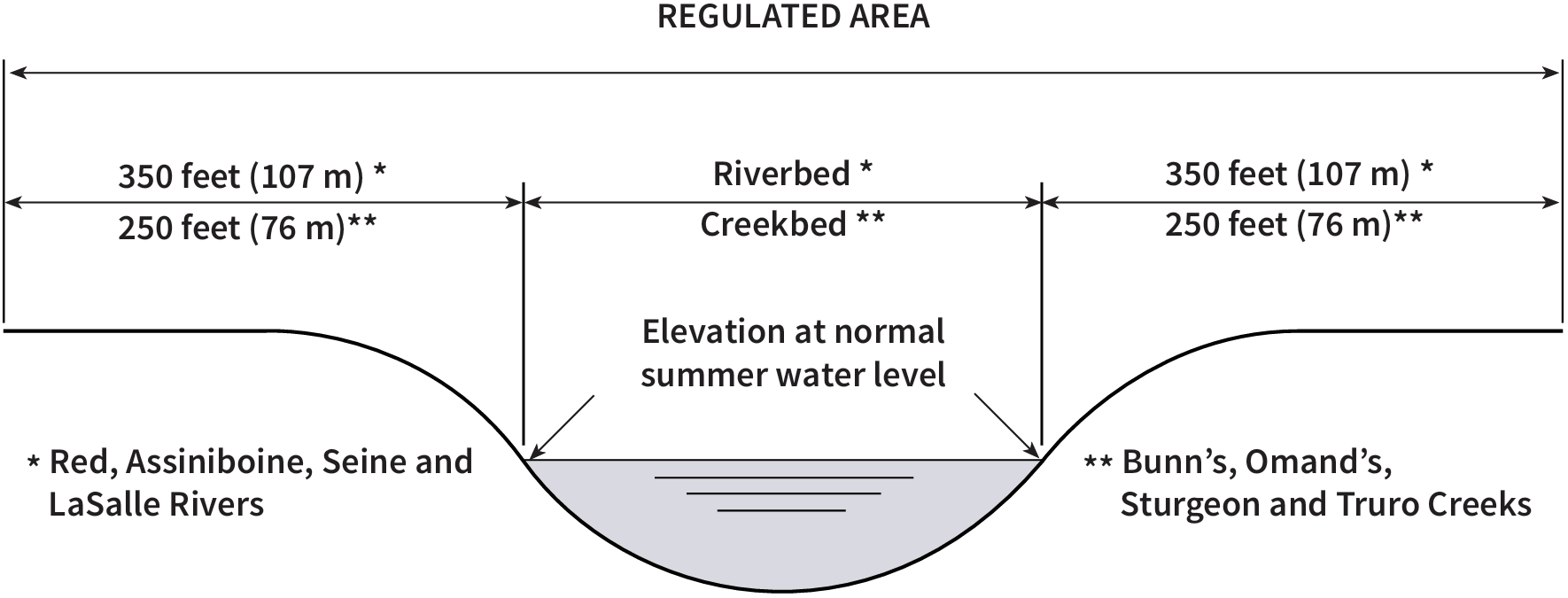
Regulated Areas
- Riverbed and lands extending 350 feet (107 m) on each side of the Red, Assiniboine, Seine and LaSalle rivers
- Creek bed and lands extending 250 feet (76 m) on each side of Bunn's, Omand's, Truro and Sturgeon creeks
Each side is measured from the edge of the river or creek at its normal summer water level.
Examples of work that require a waterway permit
- Construction or demolition of a building
- Deposit, removal, alteration or disturbance of any material
- Diversion or alteration of a waterway
- Commercial and industrial buildings
- Dwellings, additions and garages
- Swimming pools, decks, permanent docks
- Riverbank stabilization (erosion protection, retaining walls, shear keys, etc.)
- Landscaping work that changes the ground level, adds retaining walls or other retaining structures, or changes where surface water flows.
Additional approvals before getting a waterway permit
Before applying, make sure you have completed any prerequisite approvals for your project, such as:
- Other approvals – Your project may need additional permits or approvals, such as zoning variance, building permit, development permit, or approval under the Floodway Fringe Area Regulation.
- Winter construction – Work on frozen waterways requires a frozen waterway permit, also available through Permits Direct Line at 204-986-5140.
To find out if you need other approvals, call the Permits Direct Line at 204-986-5140.
Note: Driving or building any structure on ice without a frozen waterway permit is not allowed.
Supporting materials for waterway permit application
Before submitting your waterway permit application, prepare the application form and include supporting materials. Some submissions may require hard copies if requested. Applications will not be processed until all required documentation is received.
Site plan should include:
- Date and version number
- Legal description, scale, and lot dimensions
- Dimensions and location of existing structures and proposed works relative to the property lines
- Location of waterway relative to proposed works
- Any modifications to site drainage
Construction drawings (not preliminary plans) should include:
- Date, version number, and scale
- Existing and proposed foundation details clearly marked
- Existing and proposed construction elements clearly marked
- Building elevations
- Landscaping plans and grading, showing all existing and proposed structures
- Any other relevant information
We may request a lot grade plan prepared by a Manitoba Land Surveyor or Professional Engineer. Lot grade plans should include:
- Slope changes and high/low ground points
- Existing and proposed building outlines, clearly shown differently
- Existing and proposed elevations* of all ground changes, shown separately
- Existing and proposed elevations* around the structures and along property lines (based on the same survey reference)
- Location of downspouts and sump pump discharge
Cross sections (if requested) should include:
- Surveyed points along a line representing the minimum distance to the waterway
- Existing and proposed building outlines, and existing and proposed elevations* of basement and ground floor
- Existing and proposed elevations* along the length of the cross section, showing any cut/fill area
- Multiple cross sections may be required
*Elevations must be based on a professional survey and tied to an official named reference level.
You may need a geotechnical engineer’s report, depending on how complex your project is, the level of risk, and the condition of the riverbank. The engineer will decide what type of report is needed.
It could be a brief professional opinion, an office (desk) review, or a detailed geotechnical study. The report must be written and stamped (sealed) by a qualified Professional Engineer who specializes in geotechnical engineering and is licensed by Engineers Geoscientists Manitoba to work in Manitoba.
Safety & stability tips
Work in Regulated Areas:
- Get a waterway permit first – Don’t start any work, including:
- Depositing fill (soil, rock, concrete, tires, etc.)
- Building or demolishing structures (homes, additions, garages, decks, pools, commercial/industrial buildings)
- Riverbank improvement or stabilization
- Lot grade changes, major landscaping pathways, retaining walls, etc.
- Do not risk doing work without a permit – Unauthorized work can increase the chance of riverbank failure. This may result in a Waterway Order to remove materials or restore the site at your expense.
- Seek professional advice - Consider consulting a Geotechnical Engineer. Their review can protect your investment and support your waterway permit application.
- Collaborate with neighbours – Riverbank stability affects multiple properties. Working together can reduce costs and improve results.
Work in Designated Floodway Fringe Area
If the works are in the Designated Floodway Fringe Area, flood proofing measures are required per Regulation 266/91. For further information, call Permits Direct Line at 204-986-5140.
Application review
- Review time depends on application complexity and volume.
- If you disagree with the Riverbank Management Branch’s decision, you can send a written notice of appeal to the Standing Policy Committee Clerk at:
- Standing Policy Committee on Water, Waste and Environment
City Clerks Department
510 Main Street
Winnipeg, Manitoba, R3B 1B9
- Standing Policy Committee on Water, Waste and Environment