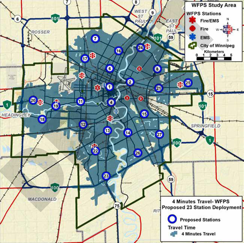
The Community Risk Assessment Standards of Cover proposes that operating fewer WFPS stations (a reduction from 30 stations to 23, plus a proposed net new station in Waverley West) properly positioned and configured could improve response performance over the current model.
The repositioning of the facilities provides greater balance in travel time coverage over the current deployment, and the opportunity to remodel, reconfigure, or rebuild stations with a focus on egress from all areas of the station for improved turnout time. Both improve total response time.
Using the proposed station deployment model (excluding the proposed net new Waverley West station), nearly 98 percent of 2016 emergency incidents are within four minutes travel or less of a WFPS station. This represents a slight improvement over the current station deployment (97.2 percent). It also achieves slightly better emergency service demand coverage.
Using FUS criteria (excluding the proposed net new Waverley West station), the proposed station deployment model would ensure 99 percent of commercial and industrial properties would be within five kilometers driving distance of a proposed station location, and 99 percent of one or two family detached residential, and multi-family residential properties within eight kilometers.
In concert with emergency vehicle traffic pre-emption, fewer but larger, properly located, and more efficiently designed stations will improve current response times and ensure that future demands are met.
Any proposed changes to station deployment would be subject to Council approval of the plan and budget, and predicated on the implementation of an emergency vehicle traffic pre-emption system.