Chief Peguis Trail Extension West
From Main Street to Brookside Boulevard
This study is now complete
Cette étude est terminée
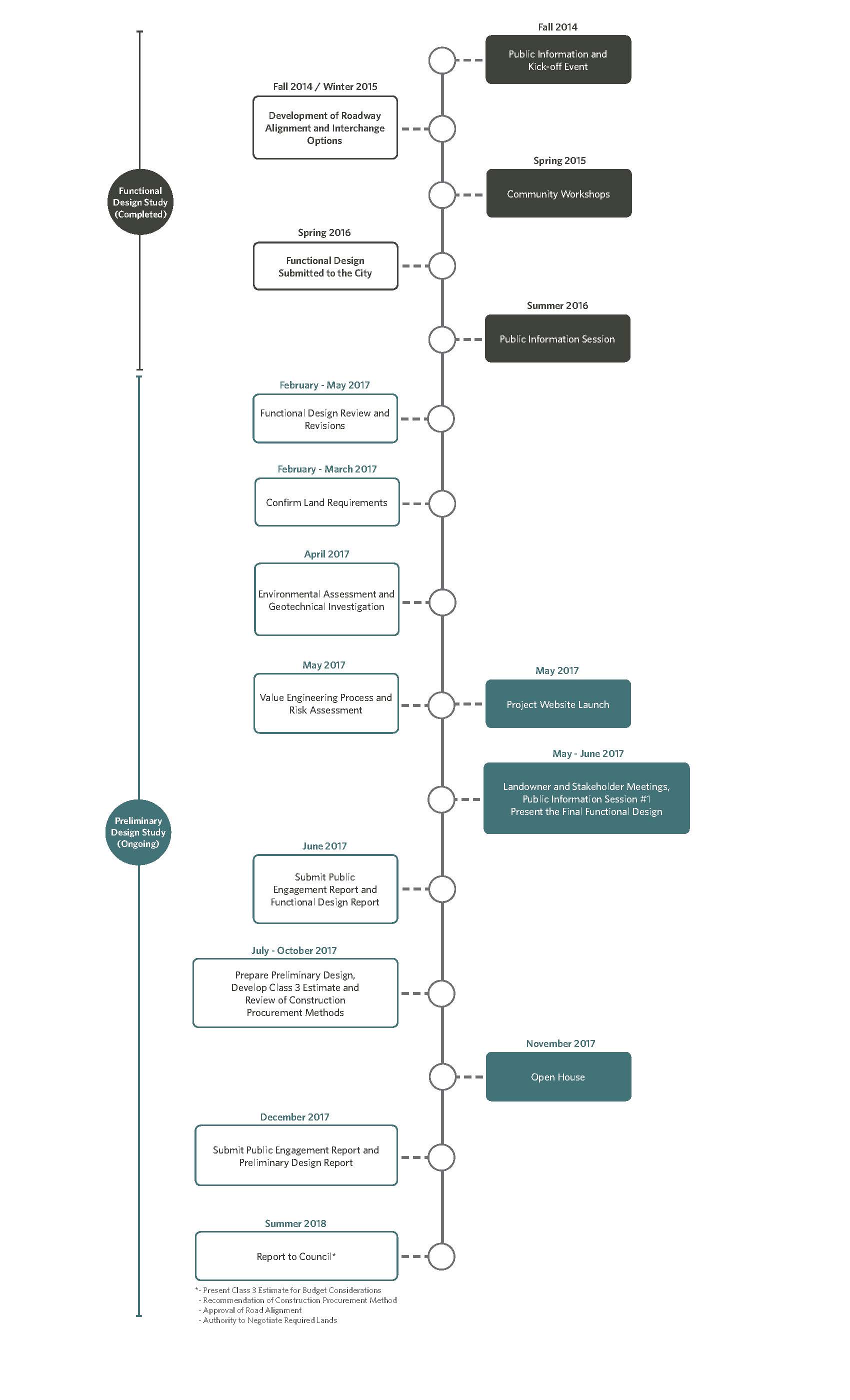
From 2014 to 2016, a Functional Design Study was conducted for the Chief Peguis Trail (CPT) Extension West. The intent of the study was to gain insight into the use and expectations for the CPT Extension West from Main Street to Brookside Boulevard. The CPT Extension West will be approximately 10 kilometers in length and will support economic development, create recreational opportunities, and support the completion of the Strategic Inner Ring Road to reduce traffic on neighborhood streets to make them more accommodating for public transit, walking and cycling.
A Preliminary Design Study is now being completed for the CPT Extension West.
The Preliminary Design Study will recommend a final design for the CPT Extension West from Main Street to Brookside Boulevard. The design will:
- Accommodate forecast traffic flow on CPT;
- Relieve traffic on neighbourhood streets;
- Provide connections to surrounding neighbourhoods;
- Include pedestrian and cycling infrastructure along the route and connections to community destinations;
- Include potential locations for public art; and,
- Limit the loss of higher quality natural areas.
- Updates
- Engage
- Background
- Timeline
- Documents
- FAQs
- Maps
- Videos
- Related Links
Updates
June, 2019 - An administrative report was presented to council at the June 20, 2019 meeting, with a recommendation that the Chief Peguis Trail Extension West project be considered and prioritized amongst other major unfunded capital projects through development of a City Infrastructure Plan. This recommendation was accepted by council. The minutes of the meeting are available here. The project timing projection will be updated as part of the upcoming Transportation Master Plan review, and presented as part of the final document of that study.
May 2019 - An administrative report outlining recommendations for the Chief Peguis Trail Extension West has been developed. The report will be presented at a meeting of the Standing Policy Committee on Infrastructure Renewal and Public Works (SPC-IRPW) on May 28, 2019. An executive summary of the project report, updated design drawings, and report on property requirements are now available under the documents tab.
As part of the decision-making and report review process, there is an opportunity for members of the public to appear as delegations at the SPC-IRPW meeting. The meeting agenda is now available online.
October 2018 - A draft preliminary design was presented to the public for feedback as part of the study of CPTEW from Main Street to Brookside Boulevard at an open house on November 7, 2017. Since then, the preliminary design is being further refined and is expected to be completed later this year, after which an Administrative Report with recommendations will be presented for Council's consideration.
March 2018 - The preliminary design is expected to be complete by late spring/early summer 2018. Following the conclusion of the preliminary design, an Administration Report will be presented to Council.
Engage
Engagement during this phase of the project is now complete. A public engagement report is now available within the documents tab of this project page.
Thank you to the more than 400 people who came out to view a video simulation of the proposed route and ask questions at an information session at the Red River Community Centre on November 7, 2017. At the event we received over 160 exit surveys. The final round of public engagement in November 2017 also included another series of land owner and stakeholder meetings.
View the information session boards.
The intent of the public engagement process for the Preliminary Design Study was to provide information and collect local feedback to:
- Inform the community and stakeholders of the intended plans and share any changes to the design;
- Help plan pedestrian and cycling infrastructure and amenities;
- Help identify connections to community destinations;
- Ensure the project complements adjacent development;
- Address the requirements of the Environmental License; and,
- Meet with affected landowners and identify property requirements.
Previous Engagement
From 2014 to 2016, four public engagement events were held to collect feedback for the Chief Peguis Trail Extension West Functional Design Study. A public information session held on June 29, 2016 at Red River Community Centre had 244 people in attendance. An online survey closed on July 12, 2016 with 84 responses. Comments received through this public engagement process indicated a repeated desire for an uninterrupted flow of traffic and fewer traffic lights; this feedback was considered in the latest phase of the design. Read more about what was said during previous public engagement activities under the related links tab.
Following the 2016 engagement events, a series of landowner and stakeholder meetings were facilitated from February 2017 to June 2017, including a public information session which was held on June 6, 2017 at the Red River Community Centre, where 244 individuals signed-in and 113 comment forms were collected. An online survey received 112 responses. A summary of these engagement events and the feedback received from the public, stakeholder and landowners is available online here.
Background
The City of Winnipeg Transportation Master Plan (TMP) identifies the CPT as a major transportation facility and an important component of the City’s strategic road network. The ultimate completion of the CPT Extension West will provide a continuous east-west link between Brookside Boulevard (Route 90) and Perimeter Highway (PTH 101). The CPT Extension West will support economic development, create recreational opportunities, and support the completion of the Strategic Inner Ring Road to reduce traffic on neighborhood streets to make them more accommodating for public transit, walking and cycling.
The City's TMP identified the western extension of the CPT between Main Street and McPhillips Street as a medium term project to be implemented by 2021, and a further western extension between McPhillips Street and Brookside Boulevard (Route 90) as a long term project to be implemented by 2031. On April 25, 2012 City Council approved an amendment to the TMP, which resulted in the CPT between Main Street and Brookside Boulevard becoming a short term project.
From 2014 to 2016, the City completed the Functional Design Study for the CPT Extension West and hosted public engagement events to gain insight into the use and expectations for the extension from Main Street to Brookside Boulevard. A Preliminary Design Study is now being undertaken for the CPT Extension West.
Documents
| Document Name | Date | Type |
|---|---|---|
| Functional Design Study: Kick-Off Event Information Boards | 2014-11-25 | Storyboards |
| Functional Design Study: Kick-Off Event Invitation | 2014-11-25 | Community Letter |
| Functional Design Study: Public Workshop Information Boards | 2015-06-03 | Storyboards |
| Functional Design Study: Map | 2016-06-03 | Map |
| Functional Design Study: Public Information Session Boards | 2016-06-29 | Storyboards |
| Functional Design Study: Project Newsletter | 2016-06-03 | Newsletter |
| Phase 1: Public Information Session Boards | 2017-06-06 | Storyboards |
| Phase 1: News Release | 2017-05-25 | News Release |
| Phase 1: Table Maps | 2017-05-26 | Maps |
| Phase 1: Public Engagement Report | 2017-08-14 | Report |
| Phase 1: Public Engagement Summary | 2017-08-15 | Report |
| Phase 2: Public Information Session Boards | 2017-11-07 | Storyboards |
| Phase 2: News Release | 2017-10-26 | News Release |
| Phase 2: Table Maps | 2017-10-26 | Maps |
| Phase 2: Public Engagement Report | 2018-01-03 | Report |
| Executive Summary | 2019-05-22 | Report |
| Design Drawings | 2019-05-22 | Maps |
| Property Requirements | 2019-05-22 | Report |
| Council Minutes | 2019-06-20 | Minutes |
Frequently Asked Questions
This study will prepare a recommended final design for the CPT Extension West from Main Street to Brookside Boulevard. The design will:
- Provide efficient traffic flow on CPT;
- Relieve traffic on neighbourhood streets;
- Provide connections to surrounding neighbourhoods;
- Include pedestrian and cycling infrastructure along the route and connections to community destinations;
- Include potential locations for public art; and,
- Limit the loss of higher quality natural areas.
The City of Winnipeg has reserved some land along the corridor for the CPT Extension West. Where the alignment will require additional lands, meetings will be held with landowners prior to the public information session.
Little Mountain Park is outside of the study area and beyond the scope of this project. However, the alignment for CPT Extension west of Brookside Boulevard should not impact Little Mountain Park.
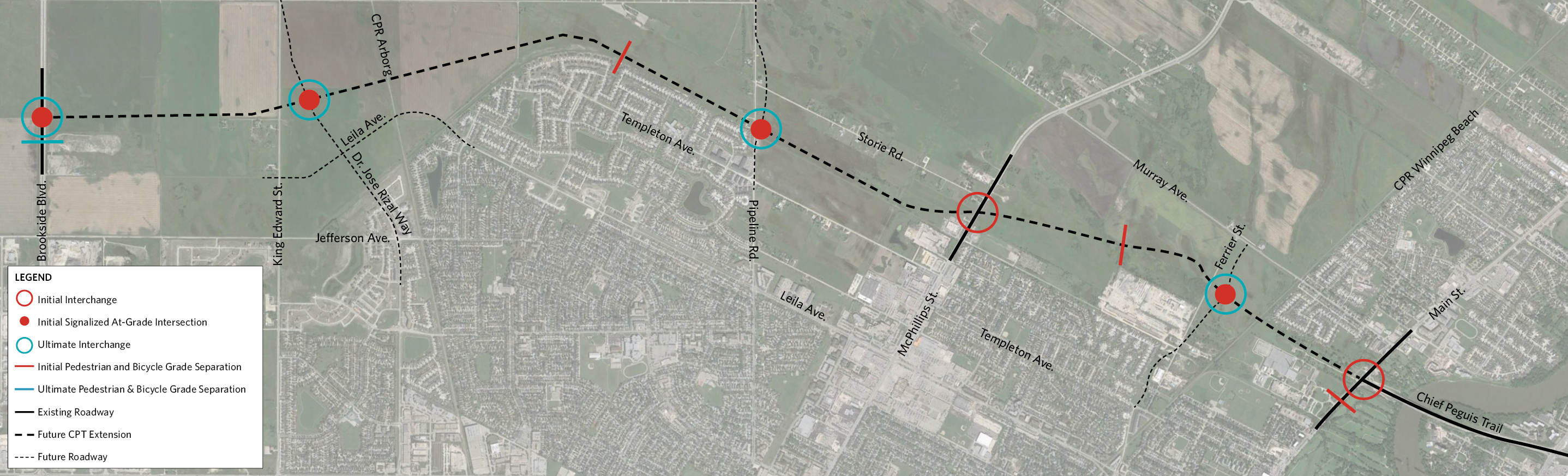
The Functional Design Study determined conceptual roadway alignments and initial interchange and intersection requirements for the CPT Extension West.
The Preliminary Design Study will confirm land requirements, address the requirements of the Environmental License, include pedestrian and cycling infrastructure, identify potential locations for park and ride lots, identify potential locations for public art, and include greater detail of all of the design elements (i.e., lane width, intersections, etc.).
A few changes have been made to the design that was presented in 2016. These changes were influenced by both technical requirements and public input and include:
- Shifting the alignment of the CPT Extension West to the north between Pipeline Road and McPhillips Street to minimize impact on the Ferrier Forest and to plan for a future interchange at Pipeline Road;
- An interchange at McPhillips Street and CPT Extension West for opening day;
- Reconfiguring the interchange at Main Street and CPT Extension West to allow free flow traffic on CPT; and,
- Other minor adjustments after additional traffic analysis was completed.
The project is subject to Council and funding approval. There is no anticipated construction date at this time.
Yes, pedestrian and cycling infrastructure will be included in the plan and will connect to existing and planned pedestrian and cycling infrastructure.
An environmental assessment is being conducted. The environmental assessment will include field visits for species of conservation concern and ecological valuation of trees, wooded areas and wetlands. An Environmental Act license is required by the Province when opening new major roadways.