Osborne to Downtown Walk Bike Bridge and Connections
This study is now complete
Cette étude est terminée
Update December 2020 – The latest phase of design is now complete.
A public engagement summary and report are now available under the Engage tab.
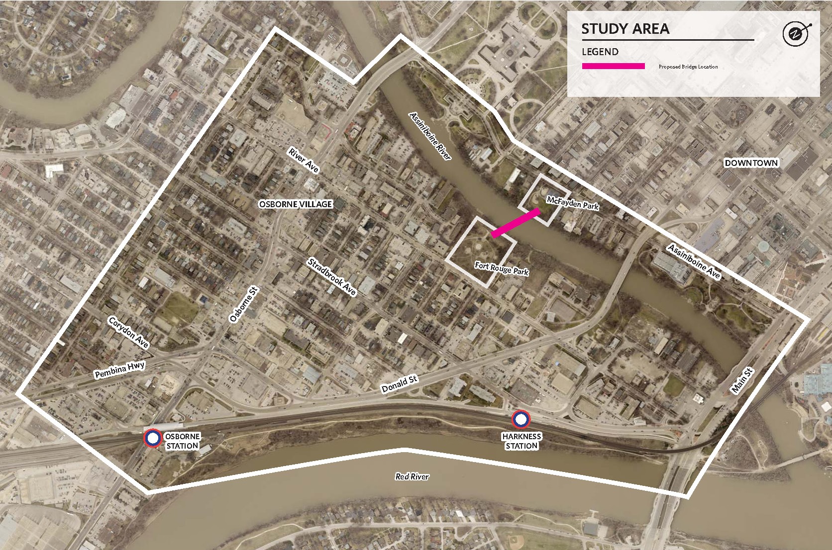
The City of Winnipeg (the City) is committed to building pedestrian and cycling infrastructure for people of all ages and abilities. Through this study, a preliminary design for a new pedestrian and cycling bridge over the Assiniboine River will be developed to connect Osborne Village to Downtown via McFadyen Park on the north side of the river and Fort Rouge Park on the south side of the river. Considerations for this project include pedestrian and cycling connectivity throughout Osborne Village to Osborne Rapid Transit Station, Norwood Bridge, bike lanes on Nassau Street, and the riverwalk, upgrades to both McFadyen Park and Fort Rouge Park, crime prevention through environmental design (CPTED), and riverbank stabilization.
Go to Public Engagement Projects Listing
- Updates
- Recommended Option-Bridge
- Recommended Option-Parks
- Recommended Option-AT Connections
- Engage
- Background
- Documents
- FAQs
- Maps
- Related Links
Updates
December 2020 - Following the public engagement and design process, the preliminary design of the bridge and parks, and functional design of pedestrian and cycling connections are now complete. Through this study, a preliminary design for a new pedestrian and cycling bridge over the Assiniboine River has been developed to connect Osborne Village to Downtown via McFadyen Park on the north side of the river and Fort Rouge Park on the south side of the river. Considerations for this project include the functional design of pedestrian and cycling connectivity throughout Osborne Village and the riverwalk. A preliminary design for upgrades to both McFadyen Park and Fort Rouge Park includes crime prevention through environmental design (CPTED), and riverbank stabilization on the south bank of the Assiniboine River.
Please visit the Recommended Option tabs to read more about the proposed designs.
Design items that are not explored at this level of design (but that will be explored in the future) are:
- Details of what the riding/walking surface of the bridge will look like.
- Details of what the signage and wayfinding on the bridge, in the parks, and on the active transportation paths will look like.
- Details of the active transportation path pavement markings, details, and colours.
The next phase of the project is detailed design of the bridge and parks and preliminary design of the cycling connections.
- The project was referred to the Unfunded Major Capital Projects list and more recent Infrastructure Plan for annual review and prioritization.
- The project will be further defined upon the completion of the Transportation Master Plan: 2050 project.
Update October 2018 - As the project team continues to refine project designs, Lewis Street and part of an adjacent back lane have been newly identified as a potential cycling connection. View the notice under the documents tab. At this time, we are reaching out to residents and businesses along this newly identified connection to ensure they are aware of the study and have an opportunity to contact the City of Winnipeg with any further questions. Before cycling connections are recommended, the project team wants to ensure local input is considered.
This route was not identified in previous phases of the project because connections to Fort Rouge Park were developed after considering public input on other major routes along River Avenue and Stradbrook Avenue.
Recommended Option-Bridge
Using the public feedback received in early 2018, the project team developed three bridge concepts for further public input.
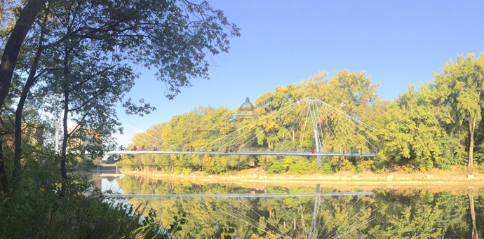
The cable-stayed curvilinear bridge was selected based on it being the bridge option that had the highest public support and best overall technical design.
See engage tab for public engagement summary and report.
The cable-stayed bridge was selected over the other two bridge options because of benefits in key technical areas:
- A shallower incline than the girder bridge which makes it more comfortable/easier to access for all types of users.
- The curved nature of the bridge also contributes to improved safety between cyclists and pedestrians as it will naturally slow rates of cycling speed.
- The cable-stayed structure of the bridge provides for improved sightlines above and below the bridge contributing to the safety of bridge and river walk users. The piers of the bridge were designed to be aesthetically pleasing with minimal footprint. Cables used above the bridge deck will be located on the inside curve of the bridge deck to provide unobstructed views and a panoramic effect.
- The bends in the bridge also make for a better fit with the aesthetics of the parks by mimicking the meandering pathways and Assiniboine River.
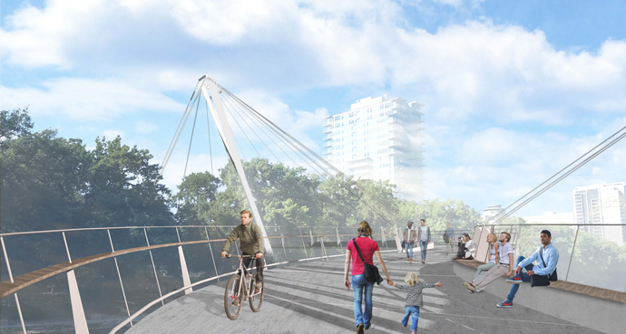
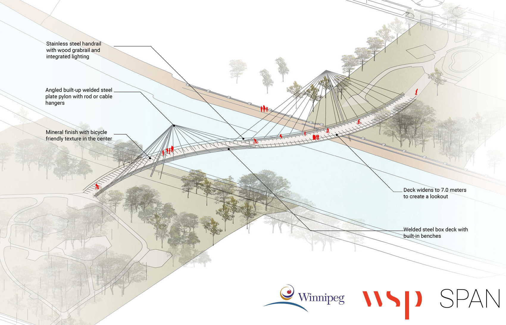
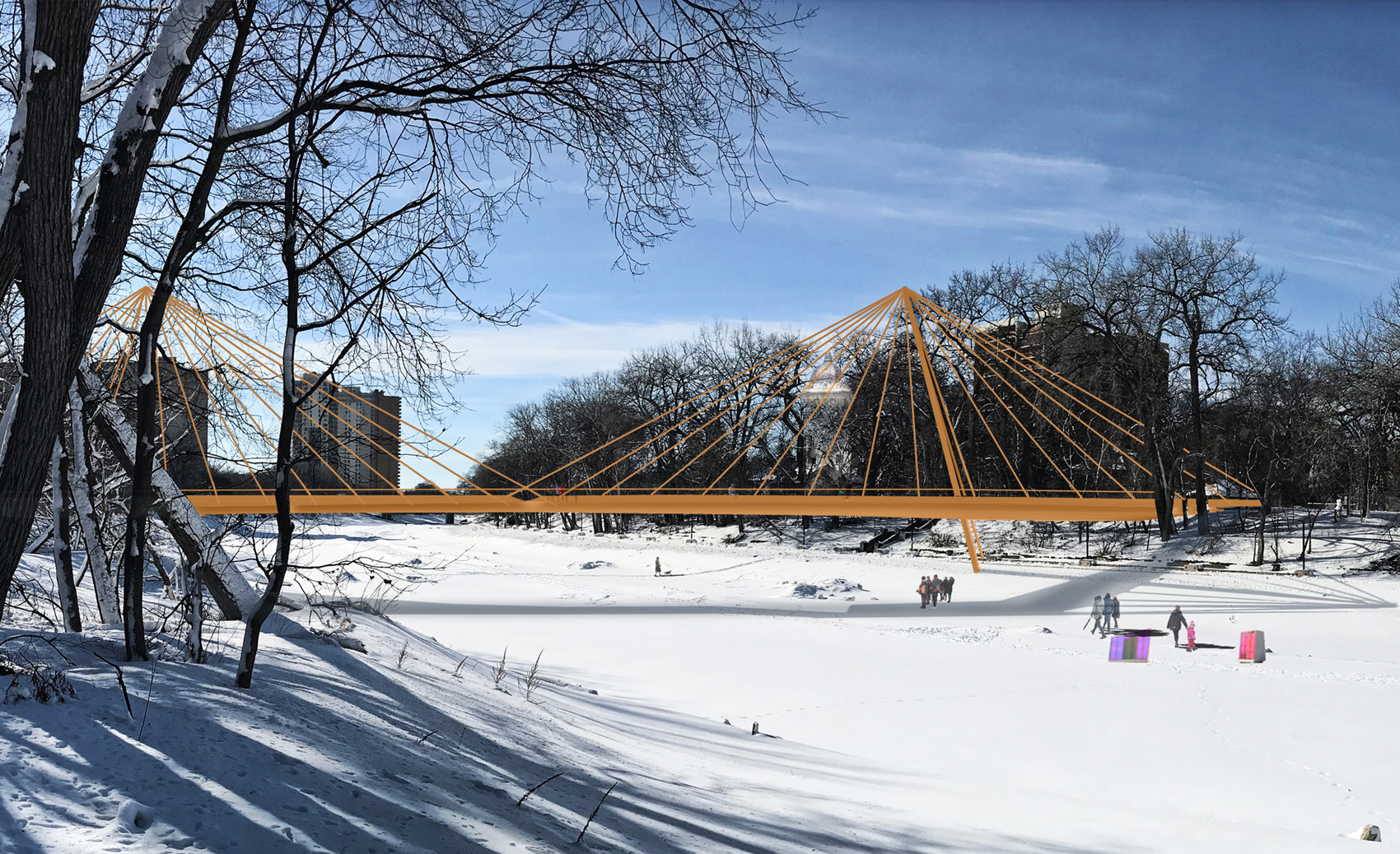
Cable-Stayed Bridge
 |
 |
 |
Key attributes specific to Bridge Option 2: Cable-Stayed Bridge
Landmark double curved bridge:
- Could attract visitors (as there are very few curvilinear cable-stayed bridges in North America, and this would be the first in Canada).
- Aesthetically unique as it allows someone on the bridge to see the other side of the bridge while crossing it.
- The double curved feature may help to provide a better "connection to the parks" feeling.
- The double curved feature will naturally help to slow down pedestrians and cyclists on the bridge (when compared to a straight bridge).
- The double curved bridge mimics the meandering rivers and streets along rivers in Winnipeg.
The centre of each of the two bridge curves gradually expands to a 7.0 m wide overlook point.
A long bench is built in to each of the inner curves
This bridge has two angled towers (near each end/abutment) that the cables connect to.
This option is more expensive than Option 1: Girder Bridge and is comparable in price to Option 3: Suspension Bridge.
The cable stays on each curved side will project shadows on the water resembling rays on sunny days.
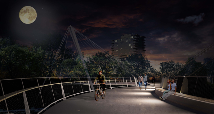
The bridge cables allow for the inclusion of artistic lighting above the bridge.
Technical consideration from Phase 1
Based on what we heard from public feedback received in early 2018, the following attributes applied to all bridge concepts presented:
- Each bridge provides a safe and efficient pedestrian and cycling connection. The design is intended for mixed-use between pedestrians and cyclists, sharing the space equally without vehicle traffic. The lack of barriers would allow pedestrians to cross to appreciate the view from each side of the bridge.
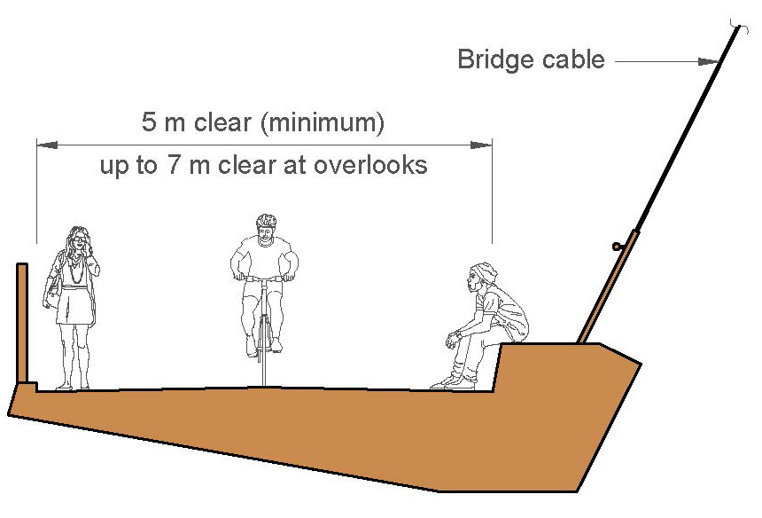
- A 5.0 m bridge width was selected in accordance with engineering guidelines to provide sufficient space for pedestrians and cyclists (including wheelchair users) to share the space. This also allows enough space for snow clearing vehicles. Note, sidewalks along Osborne Street Bridge are 2.5 m wide, while the Esplanade Riel pedestrian bridge has a similar sidewalk clearance to the proposed bridge deck at 5.0 m wide. Each bridge concept has at least one area where the bridge deck widens from 5.0 m to 7.0 m to create one or more overlook areas.
- The bridge widths and bridge approaches through the parks (and to and from bike paths/the roads beyond the parks) will be designed to reduce potential collisions. Appropriate signage will be installed to advise cyclists to slow down. Bridge surfaces will be designed as best possible to be comfortable and safe for cyclists, all types of pedestrians, in all seasons.
- A bridge architect is a key member of the design team, tasked with providing elegant, aesthetically pleasing design features for each bridge concept.
- The bridge will be designed to have gradual vertical slopes and approaches in accordance with standards from the City's Accessibility guidelines. This means that all users (cyclists, pedestrians, people in wheelchairs, people with strollers, etc.) will be able to safely use the new bridge. Accessible ramps will be constructed to provide access for people of all ages and abilities from the bridge down to the riverwalk on the McFadyen Park side. Accessible ramps will also be constructed to provide access for people of all ages and abilities from the bridge down to a potential/future water dock on the Fort Rouge Park side.
- The bridge will be designed to accommodate pedestrians, cyclists, snow clearing equipment, and large groups of people (i.e. on Canada Day to watch the fireworks at The Forks). The clearance under the bridge will be designed in accordance with navigable waters requirements for boats and above flood protection levels. This will allow for year-round use of the structure.
- The bridge railing will be designed to a height and with features safe for pedestrians and cyclists. It will not obscure the view from the bridge.
- Safety is a key aspect of the bridge concepts. There will not be any areas for someone to hide behind on the bridge and the bridge will not be covered. Adequate lighting will be provided on the bridge and off the bridge through the Parks to improve safety. Careful consideration will be given to provide safe lighting to help make the bridge safe and to make the bridge aesthetically beautiful, but to reduce light pollution. Increased public usage of this space will also increase safety. Crime prevention through environmental design (CPTED) principles will apply.
- Consideration will be taken with respect to environmental impact. The bridge options will be developed to not include any in-stream piers (columns) in order to reduce impact on the river habitat, and prevent ice jams in the spring, as well as allow for uninterrupted river flow.
- Some trees will need to be removed for construction of riverbank stabilization, to allow access to construct the bridge, and to build accessible ramps extending to the riverwalk. The design team is working to minimize the impact on existing, especially mature trees. New trees will be planted in locations surrounding the new park infrastructure. Similarly, lighting will be designed for safety but there will be an effort to minimize light pollution.
- The bridge concepts include no in-stream piers (columns), such as in the middle in the river. This is a more aesthetically pleasing design.
- All three bridge options are conceptually designed on a skewed alignment to the Assiniboine River to connect to each park at the most suitable location and to avoid a shallow underground high voltage Manitoba Hydro line that cannot be moved.
Recommended Option-Parks
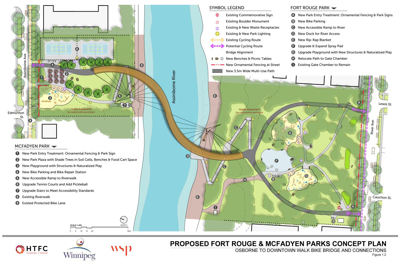
Conceptual designs of Fort Rouge and McFadyen Parks were developed based on early public feedback in 2018. Both concepts received high public support for proposed changes (online Fort Rouge Park 74 percent and McFadyen Park 75 percent.
See Engage tab for public engagement summary and report.
Changes from the designs shared in May 2018 include:
- The entry/exit point of the bridge has been shifted to the east of McFadyen Park to retain a large mown green space between the playground and pedestrian bridge for picnicking and free play;
- bike repair station was added to McFadyen Park and along with bike parking shifted closer to the street.
- Based on public requests Pickleball lines will be added the tennis courts in McFadyen Park.
- Based on public concerns raised about park safety, the number of trees within the street front plaza was reduced to increase visibility. This added open space will also create potential opportunity for food carts which was also raised at the public workshop and stakeholder meeting.
Fort Rouge Park
Changes in proposed park updates
What is being removed:
- Bollards and chain fence along River Avenue;
- Wood park sign;
- Some trees along riverbank to accommodate bridge construction, accessible ramp to river and dock. The project team will continue to work on minimizing tree loss, especially of mature trees, and new trees will be planted; and
- Swing set play area (to be replaced within new play structures).
Proposed additions:
- Improved park street-front appearance with ornamental fencing and contemporary park signs. Fence will also act as a safety feature, providing a barrier between the park and River Avenue;
- New 3.5 m wide multi-use path ‘loop‘ over existing path connecting the pedestrian bridge to River Avenue. Width may vary to minimize impact on mature tree roots;
- New bike parking to accommodate bike traffic and bike storage and make the park a destination point for users of all ages;
- New accessible path and ramp to provide barrier-free access to dock at river;
- New river edge dock for fishing, canoe launch, potential water taxi stop in summer and access to river trail in winter;
- New rip-rap to enhance riverbank stabilization and help mitigate future erosion;
- Upgraded and expanded spray pad to accommodate new users crossing over the bridge from McFadyen Park. Will include a new water line service;
- Upgrades and expand playgrounds with new structures and naturalized play including: swing sets, slides, climbers, spinners, logs, water, sand, mud, climbing boulders, hills and trees;
- Re-surfacing of asphalt pathways;
- All current light fixtures will remain and lights will be added to the accessible ramp and dock;
- New tree planting to enhance riverbank and park features and to achieve no net loss of trees on site; and
- Relocation of granular access road to gate chamber.
McFadyen Park
Changes in proposed park updates
What is being removed:
- Wading pool due to low utilization;
- Washroom building as it is in poor condition and paired with the wading pool;
- Bollards and chain fence along Assiniboine Avenue;
- Wood park sign;
- Seating area at stairs; and
- Some trees along riverbank to accommodate bridge construction and accessible ramp. The design team is working to minimize tree loss, especially of mature trees, and new trees will be planted.
Proposed additions:
- Improved park street-front appearance with low fencing and new park sign and commemorative monument. The fence will also deter children from running across Assiniboine Avenue;
- New 3.5 m wide multi-use path connecting the pedestrian bridge to Assiniboine Avenue and the existing bike lane;
- New bike parking and bike repair station;
- Street front plaza that provides an active space closer to the street for better surveillance and street presence, acts as a traffic calming mechanism for cyclists and pedestrians moving among the playgrounds and tennis courts, separates bridge access from river access, shade trees, and opportunities to sit and watch the surrounding activities;
- New expanded playground with seating areas, structures and naturalized play including: swing sets, slides, climbers, spinners, logs, water, sand, mud, climbing boulders, hills and trees; — Re-surfacing of asphalt pathways;
- A large mown green space will be retained between the playground and pedestrian bridge for picnicking and free play;
- New bike parking to encourage lingering and make the park a destination point for users of all ages;
- New accessible path and ramp to provide barrier-free access to the Assiniboine riverwalk;
- Re-configuration and upgrading of tennis courts to include new lighting, surface, fencing and Pickleball;
- Retain existing stairs and upgrade to meet Accessibility Standards;
- Lighting will be added to the pathways leading to the pedestrian bridge and the accessible ramp to the riverbank; and
- New tree planting to enhance new park features and to achieve no net loss of trees on site.
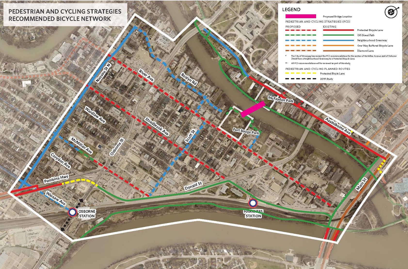
Recommended Option-AT Connections
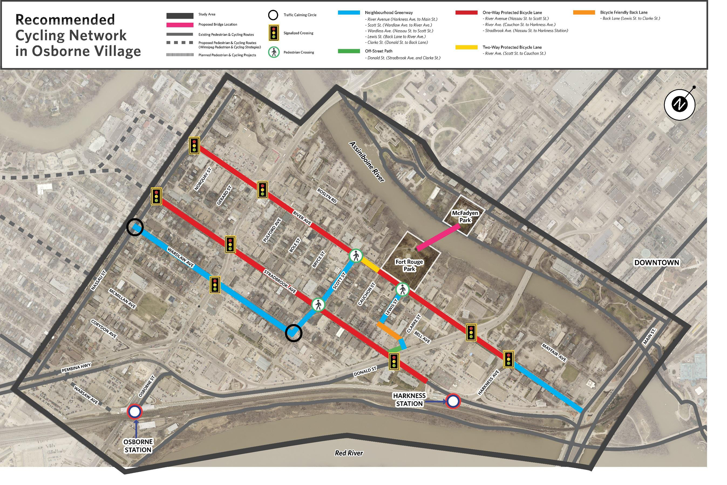
Cycling connections through Osborne Village are recommended along River Avenue, Stradbrook Avenue, Scott Street, Wardlaw Avenue, Lewis Street and adjoining back lane.
Starting with the proposed cycling routes developed by the City of Winnipeg’s Pedestrian and Cycling Strategies, analysis of public feedback from two rounds of public engagement and technical analysis has helped refine connections to a functional design level. The cycling connections of this project were designed to a functional design level, which will requires another phase of design (preliminary design) and public feedback on barriers, lane and sidewalk widths, and to confirm the locations and sizes of on-street parking, loading zones and transit stops.
See Engage tab for public engagement summary and report.
River Avenue
This route provides a safe and convenient connection to Main Street, Harkness Station (via the east sidewalk along Harkness Avenue), Fort Rouge Park (and the proposed pedestrian and cycling bridge connecting to Downtown), the proposed neighbourhood greenway on Scott Street, Osborne Village commercial hub and the existing neighbourhood greenway on Nassau Street.
- A neighbourhood greenway from Main Street to Harkness Avenue.
- A one-way protected bicycle lane on the north side between Harkness Avenue and the west entrance to Fort Rouge Park.
- A two-way protected bicycle lane on the north side between the west entrance to Fort Rouge Park and Scott Street.
- A one-way protected bicycle lane on the north side between Scott Street and Nassau Street.
- Between Nassau Street and Donald Street, parking would remain on the north lane adjacent to the bike lane but the southern curb lane would be a travel lane. The design allows for the southern curb lane to become a parking/loading lane outside of high traffic periods. There may be additional minor changes to parking improve sight lines and safety of all users. Traffic operations, parking and loading would be reassessed during the preliminary design.
Stradbrook Avenue
This route provides a safe and convenient connection to Harkness Station, the off-street path along Donald Street (which connects to Osborne Station), the proposed neighbourhood greenway on Scott Street, the Osborne Village commercial hub, and the existing neighbourhood greenway on Nassau Street.
- Construct a one-way protected bicycle lane on the south side between Nassau Street and the access to Harkness Station east of Donald Street.
- Between Osborne Street and Donald Street the parking lane would be switched from the north side to the south side of Stradbrook Avenue. The design allows for the northern curb lane to become a parking lane outside of high traffic periods. Traffic operations, parking and loading would be reassessed during the preliminary design. There may be additional minor changes to parking improve sight lines and safety of all users.
Wardlaw Avenue
This low-stress route would complement the bicycle lanes on River Avenue and Stradbrook Avenue and provide direct access to businesses on Osborne Street.
- Construct a neighbourhood greenway on Wardlaw Avenue to connect the neighbourhood greenway on Nassau Street to the proposed neighbourhood greenway on Scott Street
- No major change to on-street parking except there could be minor changes at intersections to improve sight lines and safety of all users.
Scott Street
Provides a connection to the proposed one-way bicycle lanes on River Avenue and Stradbrook Avenue and Fort Rouge Park (and the proposed pedestrian and cycling bridge connecting to Downtown).
- Construct a neighbourhood greenway from Wardlaw Avenue to River Avenue.
- No major change to on-street parking except there could be minor changes at intersections to improve sight lines and safety of all users.
Clarke Street, Back Lane (Clarke and Lewis Streets), and Lewis Street
- Widen the off-street path along the west side of Donald Street (between Stradbrook Avenue and Clarke Street).
- Construct a neighbourhood greenway on a short segment of Lewis Street.
- Construct bicycle friendly back lane (behind Stradbrook Avenue between Clarke Street and Lewis Street) and neighbourhood greenway on LewisStreet. A pilot project would need to be implemented for the bicycle friendly back lane, as it is a relatively new concept in Winnipeg.
- No major change to on-street parking except there could be minor changes at intersections to improve sight lines and safety of all users.
Engage
Thank you to all Winnipeggers who participated in the Osborne to Downtown Walk Bike Bridge and Connections project in 2018. Thank you for your collaboration and/or consideration of other participants while seeking solutions for the greatest number of residents. Your reflections and visions helped the project team arrive at better project decisions that will seek to benefit the Downtown and Osborne Village neighbourhoods.
The public engagement summary and report are now available and provides an overview of the feedback collected for the project.
If you would like to stay updated on City of Winnipeg public engagement events, follow the City on Facebook and Twitter or sign up for the City of Winnipeg public engagement newsletter.
Background
The City's Transportation Master Plan (TMP) presents a long-term strategy to guide the planning, development, renewal, and maintenance of Winnipeg’s transportation system. In 2015, City Council approved the Winnipeg Pedestrian and Cycling Strategies (PCS), which provide a long-range policy framework for active modes of transportation for the next 20 years.
The City's Pedestrian and Cycling Strategies note that the Red River, Assiniboine River, and the rail corridors create significant barriers within the walking and cycling networks, creating challenges to those navigating Winnipeg on foot or bicycle.
The Pedestrian and Cycling Strategies identifies the need for a new pedestrian and cycling crossing between McFadyen and Fort Rouge Parks along with priorities for new cycling routes in Osborne Village. The existing Osborne Street and Donald Street bridges do not provide all ages and abilities cycling connections across the Assiniboine River.
A new bridge will provide a direct, safe and convenient connection for walking and cycling downtown across the river to the Osborne Rapid Transit Station and in the future to the Southwest Transitway multi-use path. It would additionally provide a safe and convenient connection between the north and south sides of the Assiniboine River.
This crossing has the potential to be a landmark structure for Winnipeg. Key drivers include economy, functionality, constructability, architecture, and artistry. The City envisions an elegant and aesthetically pleasing, but cost effective structure. Creating connections between the wider transportation network includes a connection to Assiniboine Avenue on the north side of the river and to the Osborne Street Bus Rapid Transit Station, Nassau Street, and the Norwood Bridge on the south side.
The public engagement and design process will seek feedback on current use, values, and opportunities for improvements while also assessing potential for sharing park amenities through the new bridge connection.
Construction of this project is subject to council approval and funding.
Documents
| Document Name | Date | Type |
|---|---|---|
| Workshop invitation | 2018-01-04 | Advertisement |
| Public workshop news release | 2018-01-04 | News Release |
| Coffee shop exchange | 2018-01-04 | Postcard |
| Public Engagement Summary | 2018-05-22 | Report |
| Workshop Phase 2 invitation | 2018-05-22 | Postcard |
| Workshop Phase 2 advertisement | 2018-05-22 | Advertisement |
| Phase 2 workshop boards | 2018-06-05 | Boards |
| Lewis Street and back lane notice | 2018-10-18 | Bulletin |
| Phase two public engagement summary | 2020-12-04 | Report |
| Public engagement report | 2020-12-04 | Report |
| Public engagement report appendices | 2020-12-04 | Report |
Frequently Asked Questions
Maps