West Alexander to East Exchange Corridor
Continuing the east/west pedestrian and cycling connection to the Exchange and Downtown
This project is now complete.
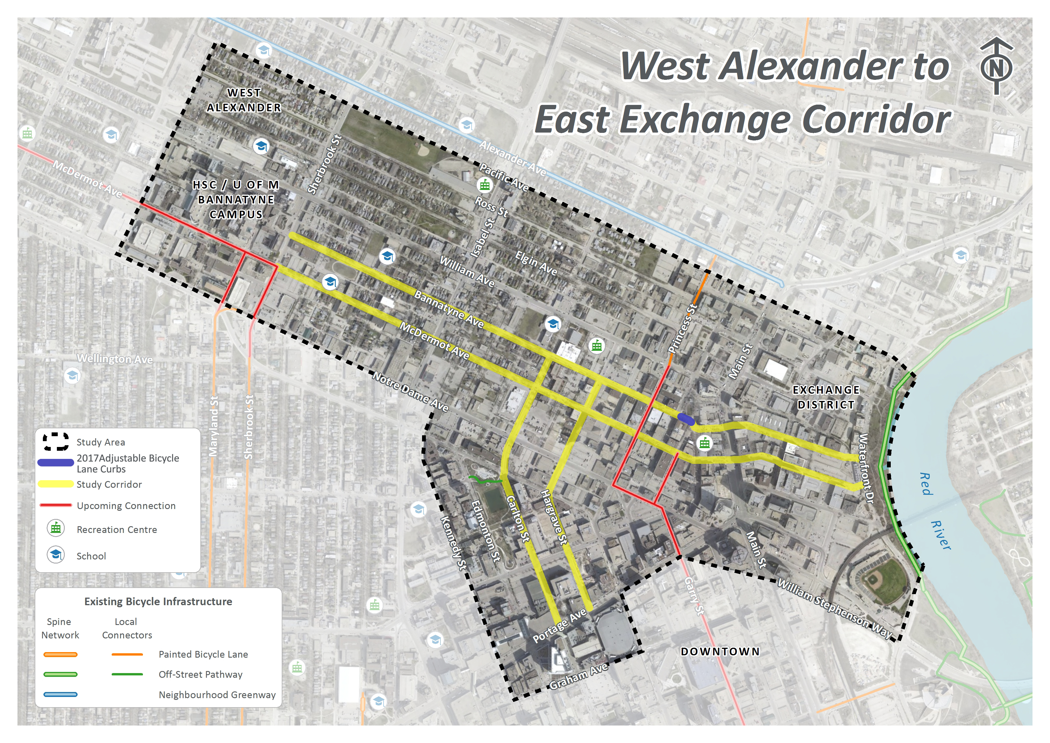
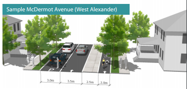
McDermot Avenue and Bannatyne Avenue provide important east-west connections between Waterfront Drive and Sherbrook Street. This project will improve the existing painted bike lanes by building one-way protected bike lanes, using adjustable bike lane curbs, on McDermot Avenue and Bannatyne Avenue in 2018. View the recommended design under the documents tab. Visit new bike infrastructure – a users guide to review new road features included in the project.
- Updates
- Recommended Design
- Engage
- Timeline
- Background
- Documents
- FAQs
- Maps
Updates
September 2018
The protected bike lanes along McDermot Avenue and Bannatyne Avenue are now open from Waterfront Drive to Sherbrook Street. The City is continuing to work on additional back-in angled parking on James Avenue, Rupert Avenue, Hargrave Street, and Albert Street. View the Detailed Design drawings.
June 2018
Construction of the West Alexander to East Exchange bike lanes has started and is progressing quickly. Stage 1 construction is expected to be completed by June 22, and work on sections Stages 2 and 3 has also started. The next steps of work on Stage 1 will include adding signs, green paint, pavement markings, and traffic signals. We thank you for your patience as we continue with this work to ensure that the bike lanes are safe for everyone.
May 2018
Construction of the West Alexander to East Exchange bike lanes is expected to start in early June 2018. The project will be completed in three stages:
- Stage 1 will include construction of the adjustable protected bike lanes on McDermot Avenue and Bannatyne Avenue between Adelaide Street and Main Street, and back-in angled parking on Adelaide Street between William Avenue and McDermot Avenue.
- Stage 2 will include construction of the adjustable protected bike lanes and back-in angled parking on McDermot Avenue and Bannatyne Avenue between Main Street and Waterfront Drive.
- Stage 3 will include construction of the adjustable protected bike lanes on McDermot Avenue and Bannatyne Avenue between Furby Street and Adelaide Street, all works on Ellen Street between Bannatyne Avenue and McDermot Avenue, and all works on Hargrave Street between Bannatyne Avenue and McDermot Avenue.
The project is expected to take approximately 12 weeks to complete. For further details please see the May construction notice.
Construction notices related to work in the project area will be posted here prior to construction. If you have questions or want to receive construction notices via email please contact Kevin Rae at AECOM Canada Ltd. 204-928-8430.
March 2018
Throughout late 2017 the project team met with adjacent property owners to help optimize the space. View the recommended design.
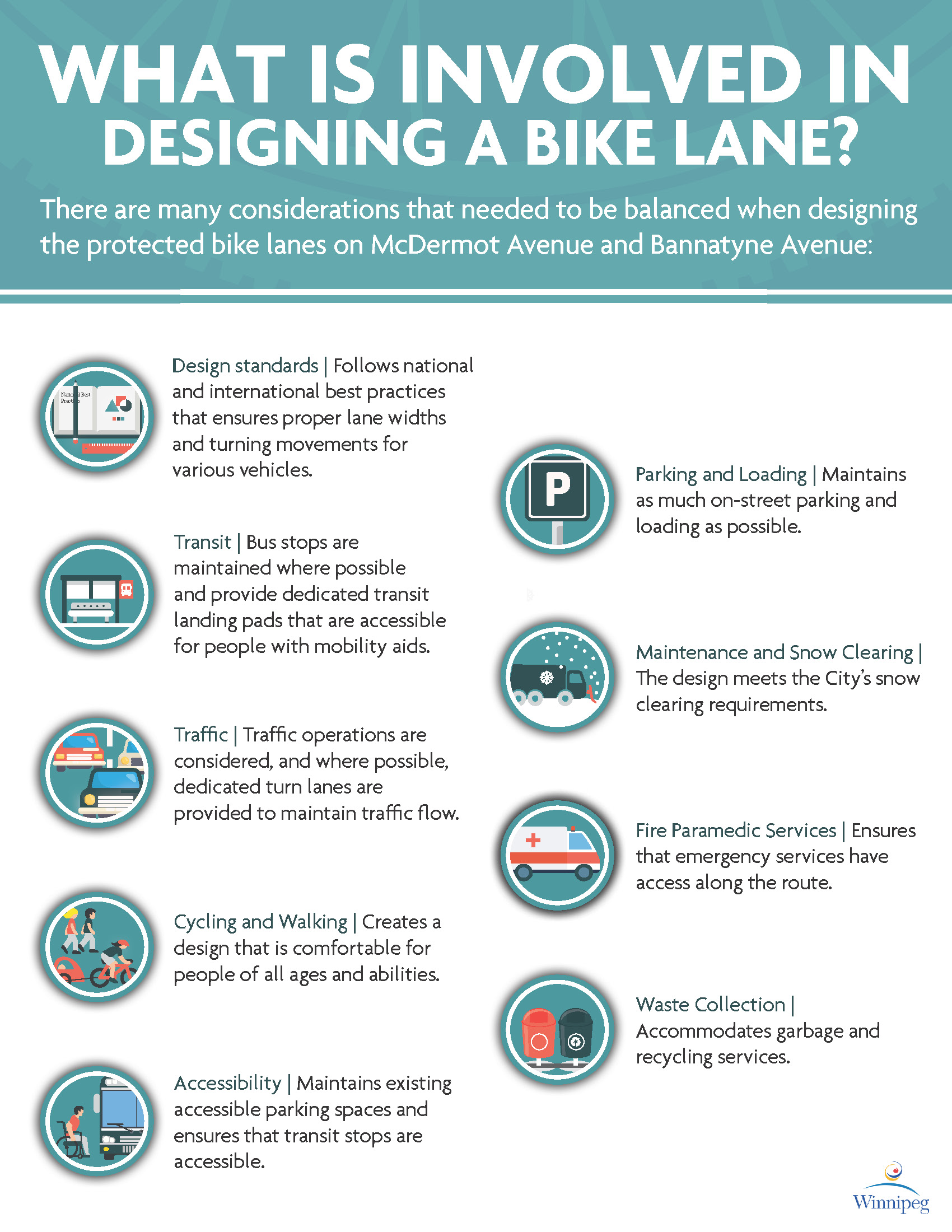
We are working to balance the needs of all users. Within the design, you will notice that in some constrained locations the buffer between the bike lanes and motor vehicle lanes has been reduced or removed to balance the needs of all users.
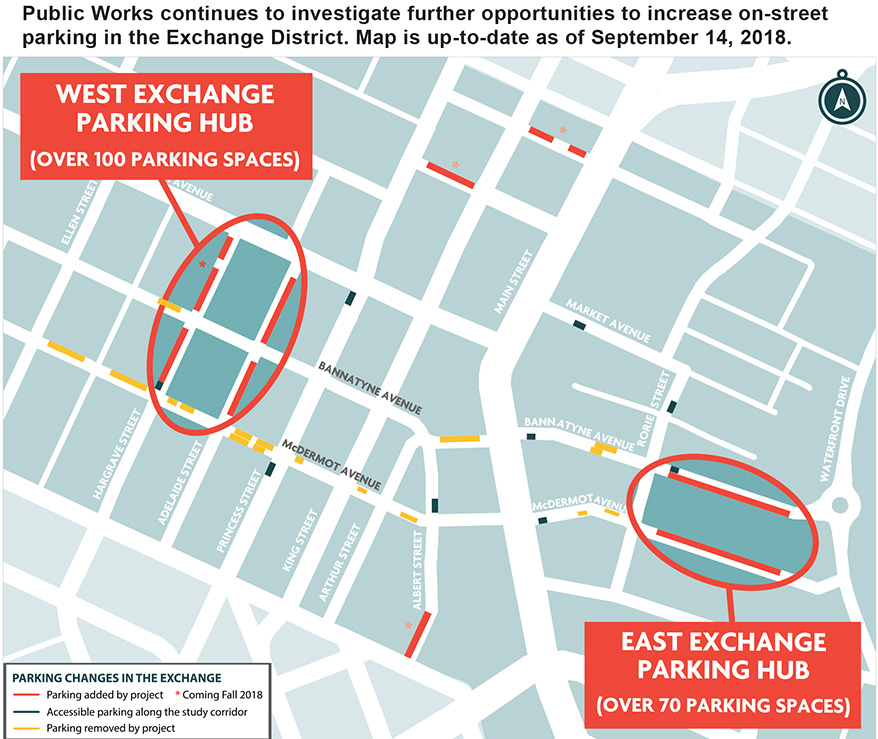
Within the recommended design, you will also notice some changes to parking. The City understands that parking is important to businesses and residents. With this in mind, we are adding parking within the area to offset the loss of some parking spots along the corridor. View a map of the parking along the corridor and for more information on where parking will be added.
Recommended Design
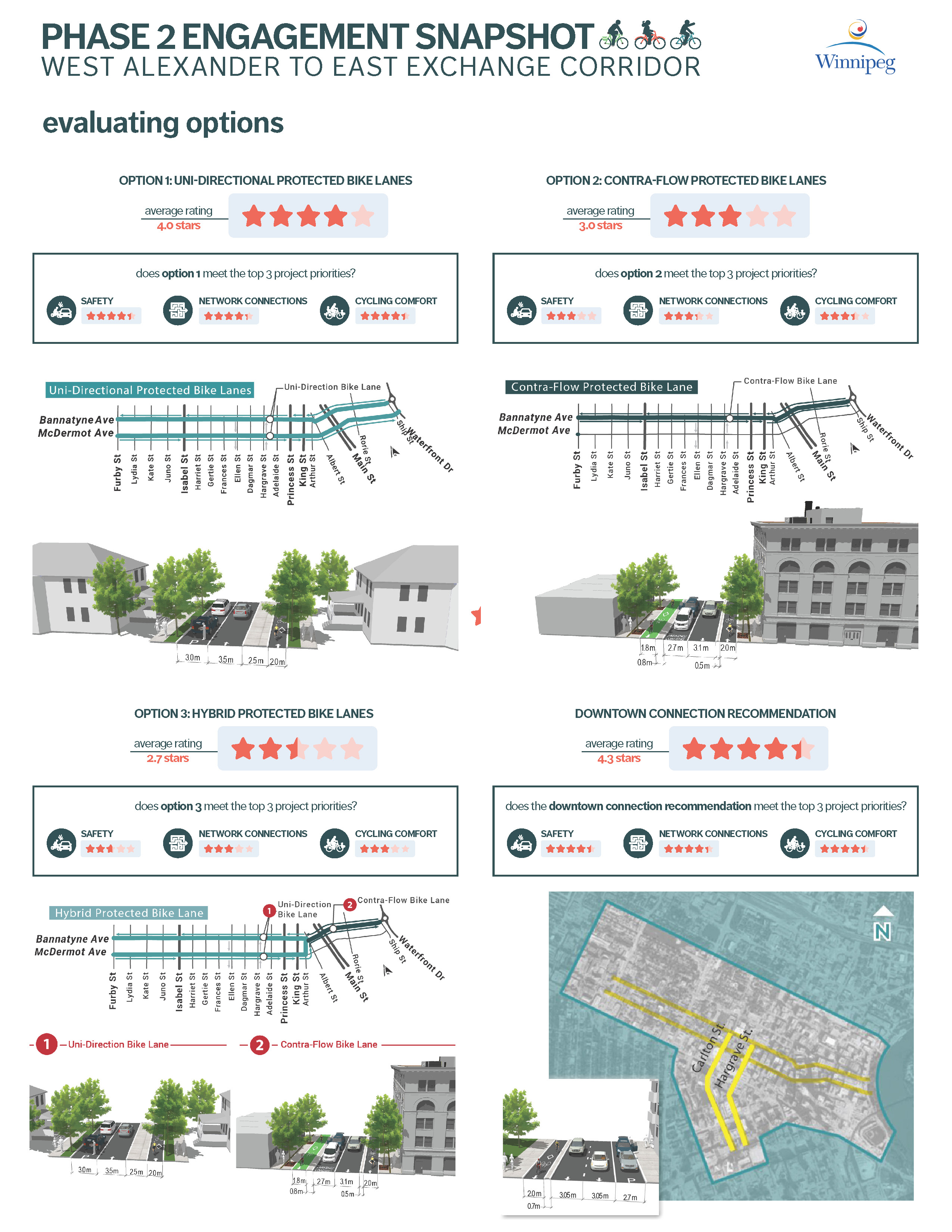
The Pedestrian and Cycling Strategies identify the West Alexander to East Exchange Corridor as a high priority for upgrading to protected bike lanes. The City has been engaging the public to receive input on what is important to consider when developing a plan. Based on public feedback and technical analysis the recommended design for the West Alexander to East Exchange Corridor is Option 1 (view all three options used for public feedback under the documents tab), which includes one-way protected bike lanes on both McDermot Avenue and Bannatyne Avenue between Waterfront Drive and Furby Street. View the recommended design. Further information on feedback provided by citizens throughout this study is available in the public engagement report available under the documents tab.
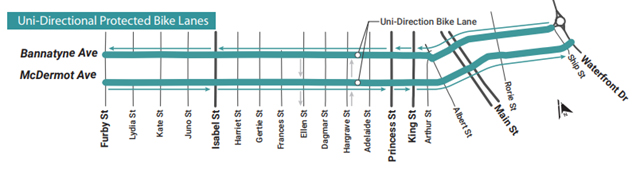
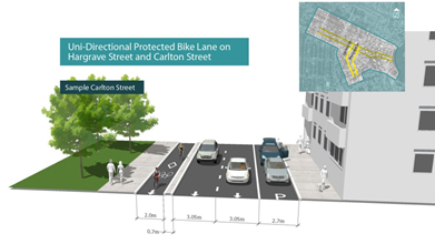
The project also includes designing a connection to downtown using Ellen/Carlton Street and Hargrave Street. The recommended design includes one-way protected bike lanes on each of Ellen/Carlton Street and Hargrave Street. In 2018, bike lanes will be constructed on Ellen Street and Hargrave between McDermot Avenue and Bannatyne Avenue only. Construction of the remaining parts of this connection will be considered for future construction seasons.
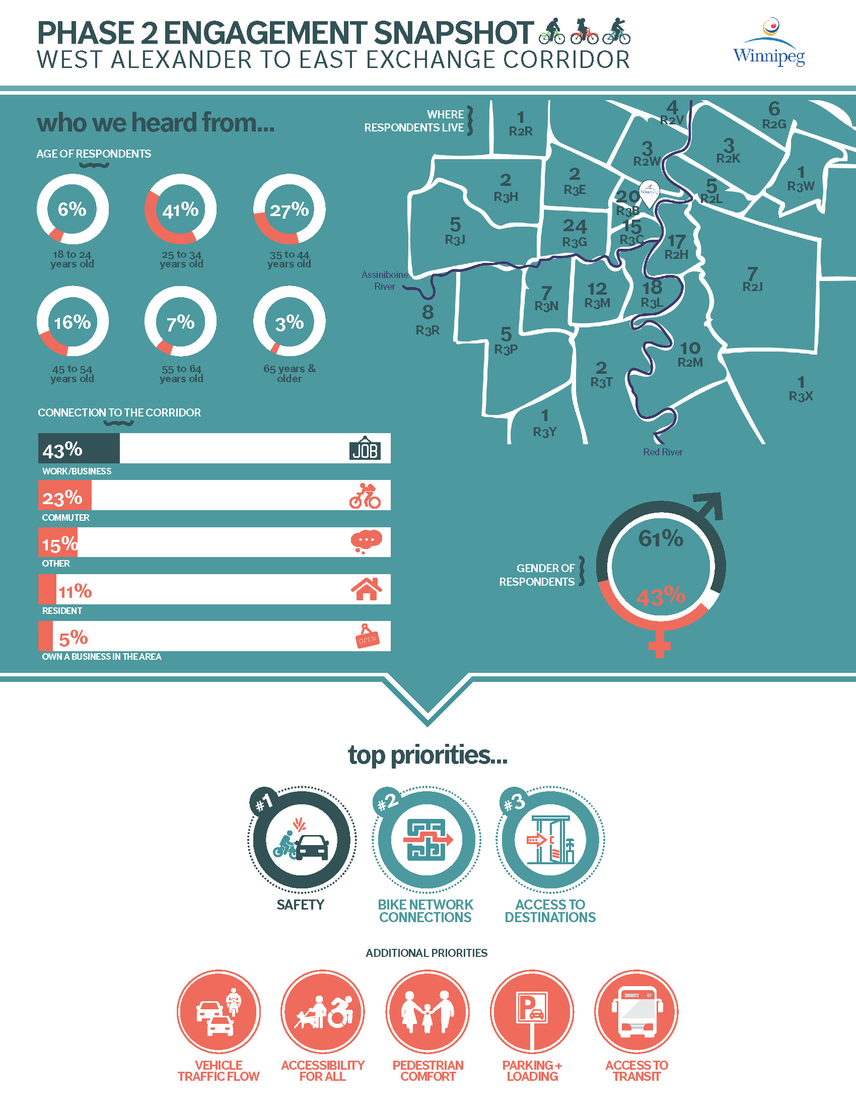
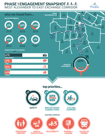
The three options used during the public engagement process were evaluated based on a number of criteria to understand the benefits and impacts on all road users. The evaluation criteria were developed after engaging with stakeholders to gather information about what is important to those who live, work and spend time in the project area. Public participants identified a number of important considerations including bicycle network connectivity, safety, bicycle comfort, pedestrian comfort, transit reliability and comfort, impacts to motor vehicle traffic, impacts to parking, maintenance and snow removal considerations, and public input. Of these, safety, bicycle network connections, and cycling comfort were identified as most important.
All options have considerations for impacts on motor vehicle traffic, transit, and parking. This option was preferred for the following reasons:
- Ranked highest based on public input in terms of safety, network connections, and cycling comfort.
- Ranked highest based on technical analysis in terms of bicycle network connections, safety and comfort.
Engage
Given the length of these streets and the magnitude of costs for permanent implementation, the protected bike lanes will be built using adjustable bike lane curbs. This adjustable infrastructure will allow for on-going monitoring and public feedback of protected bike lanes that will inform the design of the permanent infrastructure to be constructed at the time of the future street renewal.
If you would like to provide feedback on the use of adjustable curbs in Winnipeg, please contact adjustablebikelanes@winnipeg.ca or 311.
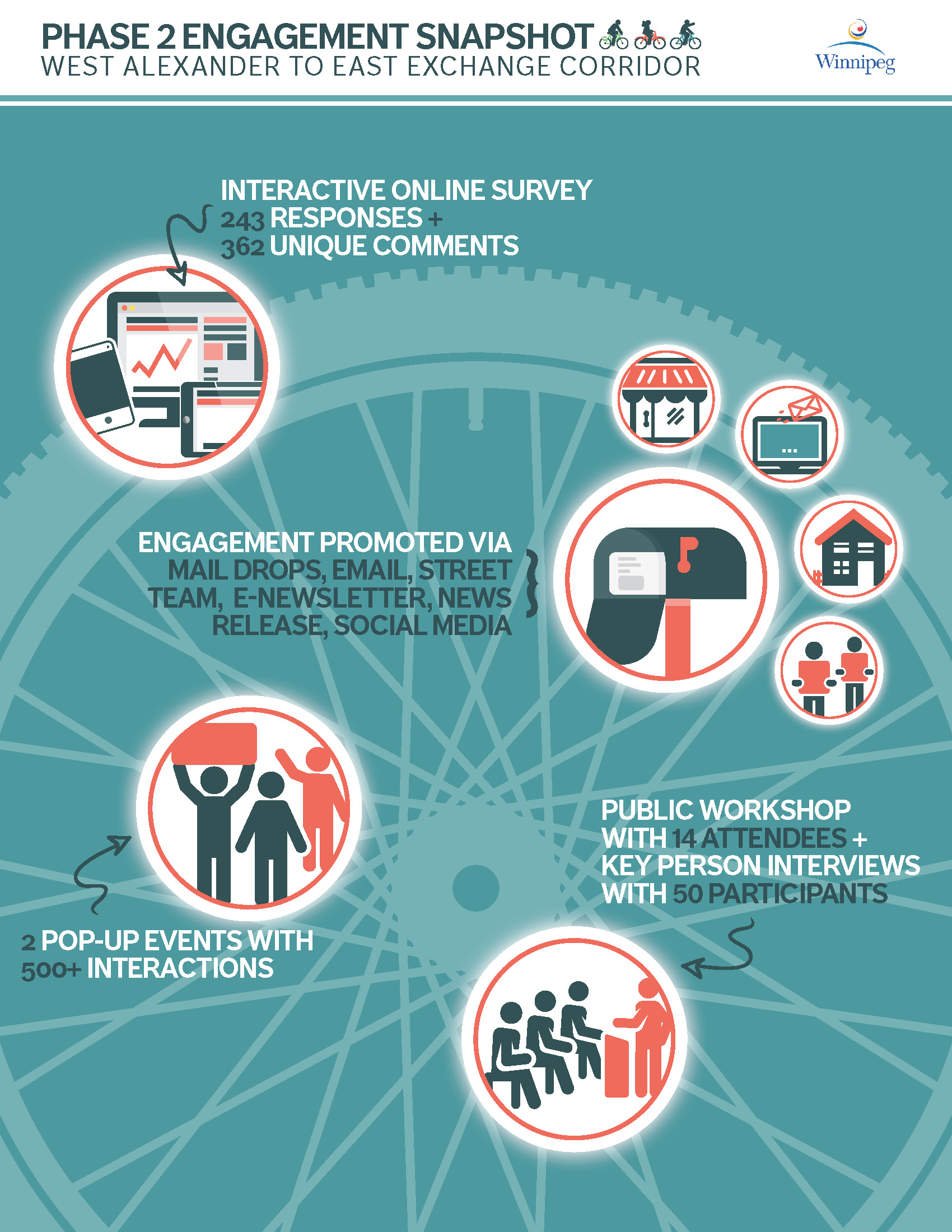
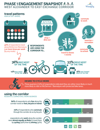
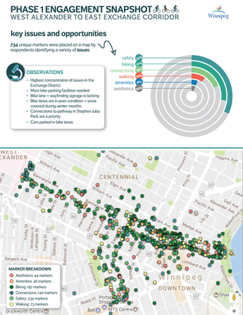
The project team sought public input through a variety of online and in-person activities in 2017. Phase 1 gathered information about key project values and objectives, current uses, and safety. This information was used to support functional design options developed in Phase 2.
Phase 2 – Results
An online survey was available from June 8 – 30, 2017 with a total 243 completed submissions.
Thank you to all who came out during Bike Week pop-up events on Tuesday, June 20 and Wednesday, June 21. Events were held at:
- Hugh John MacDonald School, 567 Bannatyne Ave.
- Old Market Square, Exchange District
Over 500 people tried out the pop-up protected bike lanes or discussed improvements with the project team.
 |
 |
 |
Phase 1- Results
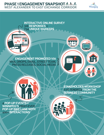
An online survey and mapping tool were available from February 1 to 21 with a total of 316 completed submissions.
Thank you to all who came out to the Bike to Work Day pop-up events on Friday, February 10. Events were held at:
- 10 a.m. to noon at Bronuts, C-100 King St.;
- 1 p.m. to 2 p.m. at Red River College, Loewen Atrium, 160 Princess St.;
- 1 p.m. to 2 p.m. at Across the Board Cafe, 211 Bannatyne Ave.; and,
- 3:30 p.m. to 5:30 p.m. at Boon Burger Cafe, 141 Bannatyne Ave.
We had over 440 interactions to discuss the improvements to bike lanes on McDermot Avenue and Bannatyne Avenue and gather information about what is important to those who live, work, and spend time in the project area.
 |
 |
 |
 |
For further information or to provide your feedback you may contact:
John Osler, Public Engagement Lead
204-942-0654
WestAlexCorr@intergroup.ca
If you would like to stay updated on City of Winnipeg public engagement events, follow the City on Facebook and Twitter or sign up for our newsletter.
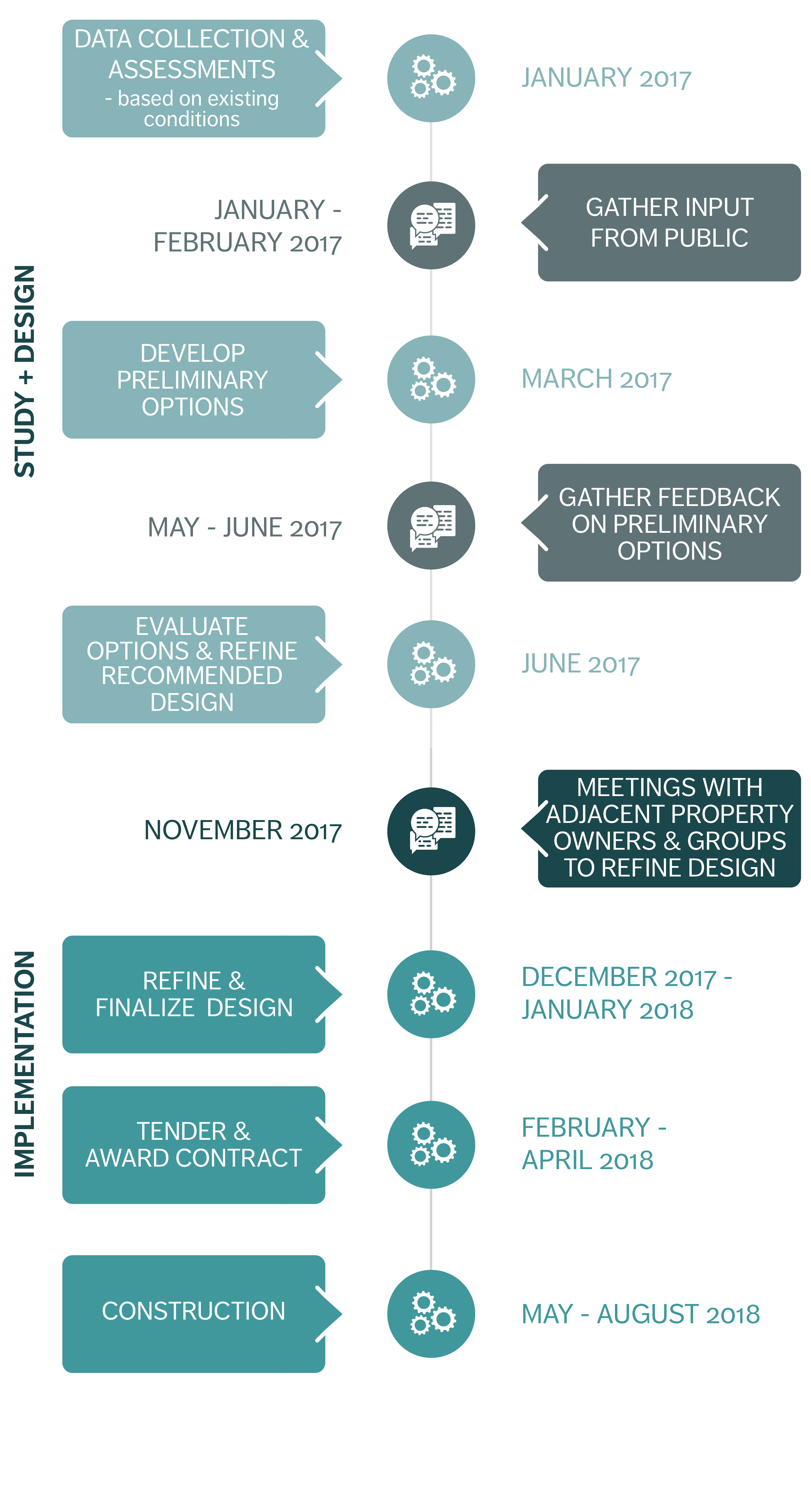
Background
- In November 2011, City of Winnipeg Council approved the Transportation Master Plan (TMP). A key goal of the TMP is to expand the range of travel options that are available to residents, workers, and visitors, as well as to ensure that people are not dependent on one single mode of transportation. The TMP also calls for the development of the Pedestrian and Cycling Strategies.
- In 2015, City Council approved the Winnipeg Pedestrian and Cycling Strategies, which provides a long-range policy framework for active modes of transportation for the next 20 years.
- In September 2015, the City of Winnipeg initiated a public engagement process to receive input on the Downtown Bike Lane System and the West Alexander Pedestrian and Cycling Corridor. Feedback received during this process has been incorporated into preferred design options, which include a two-way protected bike lane on Garry Street through the Downtown Bike Lane System and Street Improvements project and a two-way protected bike lane on McDermot Avenue between Arlington Street and Furby Street through the West Alexander Pedestrian and Cycling Corridor project. These projects are being built over the next couple of years. For more information on these projects please see the Downtown Bike Lane System and Street Improvements web page and the West Alexander Pedestrian and Cycling Corridor web page.
- In January 2017, a public engagement process was initiated to receive input on the West Alexander to East Exchange corridor to continue the east-west pedestrian and cycling connection to the Exchange and Downtown. This project is a high priority in the Pedestrian and Cycling Strategies and will improve travel choices and connectivity to the Exchange District, Downtown, Health Sciences Centre, University of Manitoba Bannatyne Campus, and neighbourhoods surrounding Sherbrook Street. View the recommended design.
- Given the length of these streets and the magnitude of costs for permanent implementation the protected bike lanes will be built using adjustable bike lane curbs. This adjustable infrastructure will allow for on-going monitoring and public feedback of protected bike lanes that will inform the design of the permanent infrastructure to be constructed at the time of the future street renewal. If you would like to provide feedback on the use of adjustable curbs in Winnipeg, please contact adjustablebikelanes@winnipeg.ca or 311.
Documents
| Document Name | Date | Type |
|---|---|---|
| Phase 1 - Popup Invite | 2017-02-01 | Community Letter |
| Phase 1 - Postcard Invite | 2017-02-01 | Community Letter |
| Phase 1 - News Release | 2017-02-01 | News Release |
| Phase 2 - Invite | 2017-06-08 | Community Letter |
| Phase 2 - Poster | 2017-06-08 | Community Letter |
| Phase 2 - Workshop Presentation | 2017-06-08 | Presentation |
| Phase 2 – Pop-up Materials | 2017-06-08 | Pop-up Materials |
| Phase 1- Public Engagement Report | 2017-06-08 | Report |
| Phase 2 – News Release | 2017-06-09 | News Release |
| Phase 2 - Public Engagement Report | 2017-09-13 | Report |
| Construction Notice | 2018-05-28 | Community Letter |
| Recommended Design | 2018-09-17 | Graphic |
| Parking in the Exchange | 2018-09-17 | Graphic |
| Project Update: West Alexander to East Exchange Corridor | 2018-08-15 | Community Letter |
Frequently Asked Questions
The project is looking at adjustable bike lanes as a solution that can be implemented in the shorter-term.