Yellow Ribbon Greenway Extension to St. Matthews Avenue
This project is now complete.
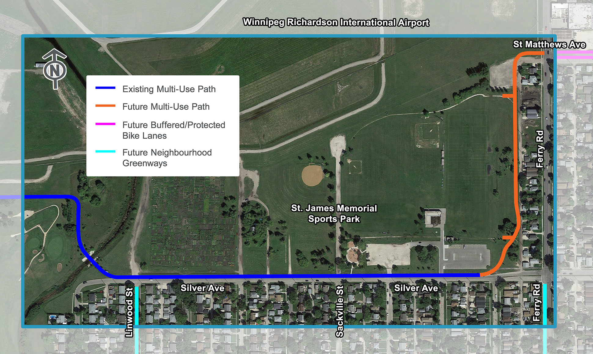
The Yellow Ribbon Greenway Extension project closes the gap in the active transportation network between the Yellow Ribbon Greenway and the St. Matthews Avenue cycling corridor. The Yellow Ribbon Greenway is an off-road pedestrian and cycling facility that connects the Sturgeon Creek Greenway to Silver Avenue. Buffered bike lanes are being constructed on St. Matthews Avenue between Century Street and Ferry Road which will enhance the cycling corridor on St. Matthews Avenue from Ferry Road to Downtown. We are looking to discuss the proposed solution on how to close a small gap in the active transportation network between the Yellow Ribbon Greenway and the St. Matthews Avenue cycling corridor from Silver Avenue to Ferry Road.
Go to Public Engagement Projects Listing.
- Engage
- Timeline
- Background
- Documents
- FAQs
- Maps
Engage
After evaluating two possible design directions to close the gap in the active transportation network between the Yellow Ribbon Trail and buffered bike lanes on St. Matthews Avenue, the project team has recommended a route using existing infrastructure along Silver Avenue and a new off-street pathway running alongside the back lane on Ferry Road. We want to share our evaluation process and refine elements of this new cycling path.
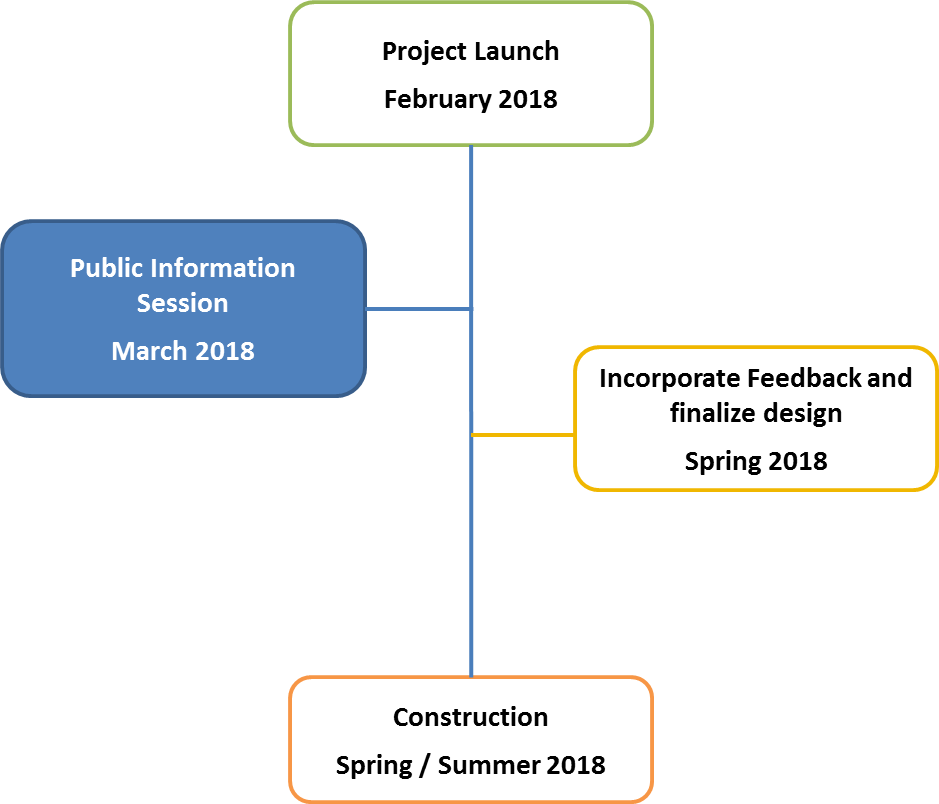
Thank you to the roughly twenty people who joined us on March 6, 2018 to discuss the project at the Bord-Aire Community Centre for a public open house. A total of ten paper surveys were collected. An online survey received two submissions. It was available on this site until March 13, 2018.
If you any questions or require alternate formats or ASL interpretation to participate, please contact Stephanie Whitehouse at 204-986-4966 or email SWhitehouse@winnipeg.ca.
If you would like to stay updated on City of Winnipeg public engagement events, follow the City on Facebook and Twitter or sign up for the City of Winnipeg public engagement newsletter.
Background
The Yellow Ribbon is a 5.5km multi-use asphalt path that runs between Hamilton Avenue and Silver Avenue. The path provides connectivity between several neighbourhoods, parks as well as to the Living Prairie Museum. For cyclist commuters, it provides an important east west connection to St. Matthews Avenue and toward Polo Park, the University of Winnipeg, and the City Centre.
In November 2011, City Council approved the Transportation Master Plan (TMP). A key underlying goal of the TMP is to expand the range of travel options that are available to residents, workers and visitors, and to ensure that people are not dependent on one single mode of transportation. The TMP also called for the development of the Pedestrian and Cycling Strategies.
In 2015, City Council approved the Winnipeg Pedestrian and Cycling Strategies (PCS), which provide a long-range policy framework for active modes of transportation for the next 20 years.
The PCS identify the need to connect the Yellow Ribbon Greenway to St. Matthews Avenue. Once completed, the buffered bike lanes on St. Matthews Avenue will provide an important east-west connection to and from key destinations such as the Polo Park commercial area, The University of Winnipeg, and Downtown. This route will also provide connectivity to many neighbourhoods, recreational paths, schools, and parks.
The Yellow Ribbon Greenway Extension to St. Matthews Avenue project will connect the Yellow Ribbon Trail to the buffered bike lanes on St. Matthews Avenue between Ferry Road and Century Street that are currently under construction, anticipated to be completed in summer 2018. St Matthews Avenue currently has painted bike lanes from Century Street to Empress Street, and at additional locations along the route to Maryland Street.
In December 2017, Council approved the Pedestrian and Cycling Program in the 2018 Capital Budget. The budget includes funds for the Yellow Ribbon Greenway Extension to St. Matthews Avenue.
Documents
| Document Name | Date | Type |
|---|---|---|
| Information session boards | 2018-02-20 | Boards |
| News release | 2018-02-22 | News release |
| Postcard | 2018-02-20 | Community invitation |
| Canstar advertisement | 2018-02-20 | Advertisements |
FAQ
Option 2 was selected because it is cost effective, can be constructed within budget in 2018, can incorporate lighting and provides improved connectivity to the community south of Silver Avenue. The additional travel time of Option 2 is also minimal (approximately 60 additional seconds based on the average speed of a cyclist).
In addition, the City's Transportation Master Plan proposes an extension of Silver Avenue from Sturgeon Road to St. Matthews Avenue as a long-term goal. The proposed road alignment runs along option 1's multi-use path. While there are no imminent plans to extend Silver Avenue, the Option 1 path would need to be removed and rebuilt if this project were to proceed in the future.