
Lord Roberts Community Traffic Study
The Lord Roberts Community Traffic Study was initiated in 2018 after residents expressed concerns about traffic speeds and volumes.
It was designed to identify community traffic concerns, validate and qualify those concerns with real data, and develop and implement solutions to improve transportation in Lord Roberts.
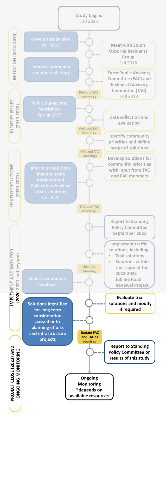
The study included five phases:
- Phase 1: Initiation (2018 -2019)
- Phase 2: Identify issues and community priorities (2019-2020)
- Phase 3: Develop solutions (2020-2021)
- Phase 4: Implement and monitor solutions (2020 – 2023 and beyond)
- Phase 5: Project close (2023) and ongoing monitoring
Details and results from Phases 1-3 were presented to the Standing Policy Committee on Public Works (SPC-PW) on September 15, 2021. A final report on the project will be presented to SPC-PW on November 21, 2023.
What we learned through this study informed the development of a community traffic calming program.
- Updates
- Solutions
- Engage
- Timeline
- Background
- Documents
- FAQs
- Maps
- Project Advisory Committees
Updates
November 15, 2023 – The pilot evaluation/community engagement summary and appendices for the time-limited parking pilot on Hethrington Avenue and Arnold Avenue is now available online.
We will present a final report on the Lord Roberts Community Traffic Study to Standing Policy Committee on Public Works on November 21, 2023.
In addition to summarizing the community study as a whole, the report outlines two pilot solutions that will be made permanent:
- Time-limited parking on Hethrington Avenue and Arnold Avenue
- School loading zone improvements on Beresford Avenue between Daly Street and Cockburn Street South
It also seeks Council approval that two other pilot solutions be made permanent:
- 30 km/h neighbourhood greenway on Cockburn Street South (between Jubilee Avenue and Kylemore Avenue)
- 30 km/h neighbourhood greenway on Walker Street (between Argue Street and Osborne Street)
If the two greenways are approved by Council, a change to the speed limit bylaw must be approved by Council at a subsequent meeting.
If you would like to appear as a delegation, please contact the City Clerk's Department by noon on November 20, 2023.
November 23, 2022 – Thank you to all those who participated in the Lord Roberts Community Traffic Study to date. Your involvement and the lessons learned from this study have resulted in recommendations to the Standing Policy Committee on Public Works (SPC-PW) on the future of neighbourhood traffic studies.
An administrative report will be presented to the SPC-PW for their consideration on November 29, 2022. The report summarizes lessons-learned from the trial neighbourhood traffic study in Lord Roberts, and recommends processes for neighbourhood intake, prioritization of candidate neighbourhoods, and study methodology.
Recommendations for the future of neighbourhood traffic studies were in part based on feedback from the Public Advisory Committee (PAC). We would like to thank PAC members for their commitment to this study and their community.
September 27, 2022 - In Fall 2018, the City of Winnipeg began the Lord Roberts Community Traffic Study to identify community concerns, gather data, and develop and implement solutions to improve transportation in the area. Through the study, we identified improving on-street parking as a community priority.
To address these concerns, we proposed a trial solution that would see two-hour time-limited parking installed on all streets in the north part of Lord Roberts for a one-year period.
Residents of the area north of Kylemore Avenue to Brandon Avenue were invited to provide feedback through an online survey from April 19 – May 10, 2022. Based on the feedback received, we adapted the proposed trial to include only Hethrington Avenue and Arnold Avenue, as residents of these streets showed higher levels of support for the trial. View the feedback report
New two-hour parking limits will be installed on these streets in October 2022. Existing time limits on Brandon Avenue, Carlaw Avenue, and Nassau Street South will remain; however, the times in which they are in effect will change.
Time-limited parking on all five streets will be in effect Monday to Friday, 7 a.m. to 5:30 p.m. for the duration of the trial.
The trial will be in place for up to one year. We will collect both traffic data and public feedback at the midway point to determine whether the solution should be implemented in the long-term or if additional changes are required.

September 17, 2021 - At its September 15, 2021 meeting, the Standing Policy Committee on Infrastructure Renewal and Public Works concurred in the public service’s recommendation to implement a series of trial solutions as part of the Lord Roberts Community Traffic Study.
Visit the solutions tab to learn more about what has been and will be implemented.
September 9, 2021 - Your feedback helped determine a plan for trialing and implementing traffic solutions. A summary of feedback from Phase 3 and the appendices are now available. An administrative report will be presented to the Standing Policy Committee on Infrastructure Renewal and Public Works for their consideration on September 15, 2021. The report provides a progress update on the Lord Roberts Community Traffic Study and outlines solutions being implemented in the next phase of the study.
If/once the proposed changes are approved, we will reach out directly to affected residents to advise of changes and plans for construction and installation.
If you would like to appear as a delegation, please contact the City Clerk's office by 4:30 p.m. on September 14.
December 14, 2020 – Thank you to all those who took the time to learn about the traffic solutions and provide feedback from November 17 to December 13. Your feedback will help to refine solutions. All those who subscribed for updates will be notified of the next steps.
November 17, 2020 - Solutions to improve traffic through the Lord Roberts neighbourhood are here! Since 2019, the project team has worked to develop solutions that address the community’s priority areas. We met with members of the Public Advisory Committee and Technical Advisory Committee to gather initial feedback on our proposed solutions and now we want to hear from you.
Learn about our plans and provide feedback on options to tell us what you prefer.
Learn more on the Solutions tab.
Get involved on the Engage tab.
July 2020 – The project team has been working on developing solution options to address the four priority areas identified by the community and through the traffic data collected in the area. We have had several meetings with the Public Advisory Committee to discuss options and will continue to work on solution options for community input this fall.
There is an opportunity to improve existing pedestrian infrastructure within the neighbourhood this summer by completing some gaps in the sidewalk network (as part of the Pedestrian and Cycling Infrastructure priority area). Winnipeg Transit has funding available to improve accessibility and a portion of this funding will go towards building sidewalks in Lord Roberts that connect to the Southwest Transitway multi-use path.
Sidewalk connections with the Southwest Transitway multi-use path will be constructed in August at the following locations:
- Berwick Court
- Walker Court
- Rathgar Avenue

Sidewalks are being constructed to fill gaps, so construction should not disrupt pedestrians. These new sidewalks will fill in missing sections of sidewalk to improve accessibility and connectivity. These sidewalks are being built this year in order to take advantage of available budget from Winnipeg Transit.
Opportunities to close additional gaps in the sidewalk network in Lord Roberts are also being explored for construction in future years.
April 2020 – The data collected in the area and public feedback told us about the highest priority traffic issues in Lord Roberts. Both the Public Advisory Committee and Technical Advisory Committee weighed in on the draft priorities in fall 2019 to develop a list of four key priority areas that will be used to develop potential solutions. The priority areas are a result of your highest priorities.
In the next phase of the study, the technical team will work on developing options to improve traffic in each of the priority areas and will ask for your feedback to refine solutions.
July 3, 2019 - The public engagement summary from Phase 2 (Identifying Issues) is now available in the Documents tab. The technical team is currently implementing a data collection plan to measure the traffic issues in the neighbourhood identified in this phase of engagement. Later this summer, the Public Advisory Committee will have their second meeting to discuss feedback and next steps. Those who signed up for updates will be kept apprised of data collection outcomes and how to get involved in Phase 3, Developing Solutions.
May 16, 2019 - Thank you to over 30 residents who attended the Lord Roberts Community Traffic Study workshop on April 29. We heard from over 400 participants online from April 15 to May 15, 2019. Your feedback on what the traffic study should accomplish and current traffic issues will help to develop a plan for collecting data on traffic in the area.
April 15, 2019 – You're invited to provide input on your experiences with traffic in the Lord Roberts neighbourhood. The feedback received by the project team will help determine what the community values most to identify possible solutions to improve transportation in the area. We want to hear from you! See the engage tab to learn more about a survey and workshop.
January 2019 – Thank you to those who applied to be on the Public Advisory Committee. Advisory Committee members have been selected and invited to their first meeting to review and revise the terms of reference and determine the PAC's goals and objectives. We are currently in the "identifying issues" phase of the project.
November 2018 – Sign up for project updates to stay up to date on the Lord Roberts Community Traffic Study. Apply to be on the project advisory committee if you would like the opportunity to work collaboratively with your neighbours and the City to identify issues and solutions throughout the study. Apply before January 2, 2019. More information on the Advisory Committee tab.
You can unsubscribe from this list anytime. Vous pouvez vous désinscrire quand vous voulez.
You can subscribe to this list again at any time. Vous pouvez vous réinscrire quand vous voulez.
Solutions
Solutions
Two trial solutions introduced in 2021 and 2022 will soon be made permanent:
- Time-limited parking on Hethrington Avenue and Arnold Avenue is now permanent
- School loading zone improvements on Beresford Avenue between Daly Street and Cockburn Street South are now permanent. We will work with the school to ensure ongoing education about the no-stopping area. Winnipeg Parking Authority will also conduct enforcement as resources allow.
An additional two solutions are being presented to Council for consideration in late 2023:
- Making permanent the Cockburn Street South neighbourhood greenway (between Jubilee Avenue and Kylemore Avenue) and reducing the speed limit to 30 km/h
- Making permanent the Walker Street neighbourhood greenway (between Argue Street and Osborne Street) and reducing the speed limit to 30 km/h
An additional 20 permanent solutions will remain in place:

- Several improvements are being made as part of the 2022/2023 Jubilee Avenue Road Renewal Project. Findings from the Lord Roberts Community Traffic Study related to Jubilee Avenue were passed onto the road renewal team.
- Pedestrian crossing improvement on Jubilee Avenue at Cockburn Street South. The signal timing plan was adjusted to provide more time to pedestrians crossing Jubilee Avenue during school-hours.
- Pedestrian crossing improvements on Jubilee Avenue at Daly Street. The signal timing plan was adjusted to provide more time to pedestrians crossing Jubilee Avenue during school hours. Pedestrian countdown signals will also be added to this intersection.
- New sidewalk on Rathgar Avenue to connect to multi-use path. The sidewalk previously ended before connecting to the multi-use path. New sidewalk has been added to improve connectivity.
- New sidewalk on Walker Court to connect to multi-use path. The sidewalk previously ended before connecting to the multi-use path. New sidewalk has been added to improve connectivity.
- New sidewalk on Berwick Court to connect to multi-use path. The sidewalk previously ended before connecting to the multi-use path. New sidewalk has been added to improve connectivity.
- New school crosswalk on Cockburn Street South at Rathgar Avenue. This intersection is patrolled and a new crosswalk will enhance visibility.
- New school crosswalk on Cockburn Street South at Beresford Avenue. This intersection is patrolled and a new crosswalk will enhance visibility.
- New school crosswalk on Daly at Beresford. This intersection is patrolled and a new crosswalk will enhance visibility.
- Boundaries of 30 km/h Reduced Speed School Zone on Daly Street South were extended to better accommodate school's operations and student travel.
- Fort Rouge Yards Construction Access. Council approved a temporary exemption to the Traffic By-law 1573/77 to allow trucks accessing Fort Rouge Yards development to use Jubilee Avenue instead of local residential streets. The exemption only applies to trucks associated with construction activity at the Fort Rouge Yards development.
- Improvements to back lane bicycle route between Arnold Avenue and Brandon Avenue. The multi-use path that extends along the Southwest Transitway passes through two back lanes in Lord Roberts. Enhanced lighting, signage, and pavement markings were installed in the lanes to improve safety for pedestrians and cyclists.
- New parking restriction to improve sightlines at pedestrian and bicycle crossing on Brandon Avenue.
- Pedestrian crossing improvement at Osborne Street and Glasgow Avenue. New pedestrian countdown signals have been installed.
- Cyclist crossing improvement at Osborne Street and Glasgow Avenue. Cyclist detection was added to this intersection so that cyclists can actuate a change to the signal in order to cross Osborne Street.
- Pedestrian crossing improvement at Osborne Street and Morley Avenue. There has been a history of pedestrian collisions at this intersection. A Leading Pedestrian Interval was installed at this intersection. A Leading Pedestrian Interval provides a head start to pedestrians crossing Osborne Street, allowing them to begin crossing before any motor vehicle traffic can proceed.
- New warning signage at Argue Street – Lilac Avenue and Rathgar Avenue intersection to advise of horizontal curve.
- Lord Roberts School agreed to promote a "walk a block" program where children who are driven are dropped off or picked up a block or more away from the school instead of at front door in order to reduce congestion.
- New parking restrictions at the pedestrian corridor on Osborne Street and Walker Avenue to provide adequate sightlines and comply with current best practice design guidance.
- New parking restrictions at pedestrian corridor on Osborne Street and Beresford Avenue to provide adequate sightlines and comply with current best practice design guidance.
- Long-term: eight solutions were developed that will be considered in the long-term as part of other projects, subject to budget availability and City-wide priority.

- New sidewalk within the neighbourhood on streets where the sidewalk ends or is only present on one side of the street, as directed by the Pedestrian and Cycling Strategies.
- New infrastructure to improve bike crossing of Osborne Street near Brandon Avenue, Glasgow Avenue and Togo Avenue.
- Safety improvements at Osborne Street and Brandon Avenue to be explored at future road renewal.
- Additional safety improvements at Osborne Street and Morley Avenue to be explored at future road renewal.
- Pedestrian crossing improvements at Osborne Street and Walker Avenue. The existing pedestrian corridor meets warrant to upgrade to a half signal.
- Pedestrian crossing improvements at Osborne Street and Beresford Avenue. The existing pedestrian corridor meets warrant to upgrade to a half signal.
- Geometric improvements to improve sightlines at the Argue Street – Lilac Street and Rathgar Avenue intersection.
- Neighbourhood educational/promotional campaign regarding parking setbacks at intersections. Some residents voiced concerns about motorists parking too close to intersections. An educational/promotional campaign could involve social media or neighbourhood flyers, explaining required parking setbacks at intersections.
Engage
Engagement on the Lord Roberts Community Traffic Study is now complete.
Engagement Plan
A public advisory committee (PAC) brought together members of the community alongside the project team to identify traffic issues and solutions.
A technical advisory committee (TAC) was also formed in this phase. The project team lead and public engagement lead acted as links between the advisory committees.
For more information about the PAC visit the advisory committee tab.
PAC meeting 1 – The first PAC meeting discussed what should be included in the study and determined the PAC's goals and objectives.
A public workshop and online survey gathered residents' feedback on traffic concerns and what they value most in their community.
PAC meeting 2 – Another PAC meeting discussed the key issues from the workshop and survey, as well as the highest priority traffic issues in the neighbourhood.
A summary of the feedback received is now available.
Feedback on what the traffic study should accomplish and current traffic issues helped to develop a plan for collecting data on traffic in the area. Information on the data collected and how to get involved in Phase 3, Developing Solutions, will be available in the coming months.
The technical team analyzed potential solutions based on community priorities, budgeted those solutions and presented feasible options.
PAC meeting 3 – The PAC discussed options for trial implementation.
This also included gathering public feedback on recommended options.
The PAC was included in decisions around how and on what to consult the broader community.
An online survey and virtual event gathered feedback to refine plans and further develop solutions that best fit the neighbourhood.
A summary of feedback and appendices are now available.
We heard from 325 survey participants and 16 community members attended the virtual event.
At its September 15, 2021 meeting, the Standing Policy Committee on Infrastructure Renewal and Public Works concurred in the public service’s recommendation to implement a series of trial solutions as part of the Lord Roberts Community Traffic Study.
Visit the solutions tab to learn more.
Standing Policy Committee on Public Works approved the recommendations of a final report on November 21, 2023. Work will continue in 2023 and 2024 to make trial solutions permanent.
Background
On June 15, 2018, the South Osborne Residents Group (SORG) submitted a request in writing to the City of Winnipeg Transportation Division for a Lord Roberts neighbourhood traffic plan. Some of the traffic concerns shared by the SORG in Lord Roberts included:
- Increased traffic volumes from new developments in the area
- On-street parking utilization and availability
- Cut-through traffic
- Transit operations
- Speed
The Lord Roberts Community Traffic Study will trial an approach to community traffic management that is collaborative, evidenced-based, and informed by best practices and technical standards. Lessons learned from the Lord Roberts Community Traffic Study approach will be carried forward to future studies and used to inform an update to the City’s community traffic management process.
The purpose of the Lord Roberts Community Traffic Study is to identify community traffic concerns, validate those concerns with real data, and develop and implement solutions to improve transportation in Lord Roberts.
- The study is a collaborative effort between community members, the City of Winnipeg, and other stakeholders identified throughout the process.
- Traffic concerns and solutions are identified through public engagement and substantiated with data collection and transportation engineering studies.
- The study considers traffic concerns of all road users.
- Traffic calming measures may be installed temporarily and monitored and evaluated prior to permanent installations.
- Public engagement, data collection, analysis, and implementation of traffic calming measures are implemented within available budgetary resources.
- The study focuses on non-regional streets within the Lord Roberts neighbourhood boundary. Issues on regional streets within the neighbourhood boundary that contribute to concerns on the non-regional streets may be identified through the study, however, improvements to the regional street network may need to be addressed through separate initiatives.
Documents
Frequently Asked Questions
The City was made aware of ongoing transportation issues in the Lord Roberts neighbourhood and committed to working collaboratively with the community to identify and implement solutions.
The Lord Roberts neighbourhood has undergone changes in the past decade and we wanted to bring the community together to identify issues and explore all different types of solutions. This collaborative and multi-disciplinary approach allowed for the best solutions to come forward for implementation.
The study focused on non-regional streets within the Lord Roberts neighbourhood boundary. Osborne Street and Jubilee Avenue were not included in the scope of this study.
The Class 4 cost estimate for most trial and immediate solutions is estimated as $139,900.
The above cost estimate does not include funding required for the following solutions:
- Solutions identified for implementation in the long term
- Improvements made as part of the 2022/2023 Jubilee Avenue Road Renewal Project.
- Findings from the Lord Roberts Community Traffic Study related to Jubilee Avenue have been passed onto the road renewal team for consideration, and would be funded by the road renewal project budget
We started implementing quick-win solutions in 2020 and continued through 2023.
Lessons learned from the Lord Roberts study approach developed a new community traffic calming program. Neighbourhoods will be looked at through this program as resources allow.
Maps

Project Advisory Committees
Project Advisory Committees
In the summer of 2020, both the PAC and the TAC provided feedback on the solutions that are proposed to go forward to Phase 4 – Implement and Monitor.
In the fall of 2019, both the PAC and TAC provided feedback on the draft priority areas developed from public feedback and data collected.
See priority areas for developing potential solutions
See responses to draft priority areas
Public Advisory Committee (PAC)
Public Advisory Committee Members
| Name | Representing |
|---|---|
| Melanie Jichuk | Resident |
| Glenn Friesen | Resident |
| Jennifer Larsen | Resident |
| Ryan Segal | Resident |
| Janis Urniezius | Local Business |
| Bill Crossman | Local Business |
| Leslie MacGillivray | Lord Roberts Community School |
| Anne Lindsey | Lord Roberts Community Centre |
| Maria Swanson | Fort Rouge Leisure Centre |
| Bev Pike | South Osborne Residents Group |
| Amanda Younka | Winnipeg Regional Health Authority |
PAC Meeting 7 – during the seventh PAC meeting, the group reflected on their experience as PAC members and provided feedback on how the study process and PAC could be improved. PAC members also completed a questionnaire to allow for anonymous feedback. See meeting notes. A summary of feedback from the PAC is available here.
PAC Meeting 6 – during the sixth PAC meeting, we discussed the solutions that are going forward for Standing Policy Committee consideration. See meeting notes
PAC Meeting 5 – during the fifth PAC meeting, we discussed solutions options for the pedestrian and cycling infrastructure and on-street parking priority areas. See meeting notes
PAC Meeting 4 – during the fourth PAC meeting, we discussed solutions options for the school area safety and other safety improvements priority areas. See meeting notes
PAC Meeting 3 – during the third PAC meeting, those who were not available for PAC meeting 2 attended the first hour to receive the overview of data collected. All PAC members were invited to attend the second hour for the priority areas discussion. See meeting notes
PAC Meeting 2 – during the second PAC meeting, the PAC received an overview of the feedback collected from the community and the data collected through the data collection plan. The PAC also reviewed the draft priority areas. Due to time constraints, the group agreed to send feedback over email and the City planned to schedule another PAC meeting to allow further discussion on priorities. See meeting notes
PAC Meeting 1 – during the first PAC meeting, the PAC received an overview of the study plan, discussed how the PAC would function, advised on next steps and promotion, and revised the draft Terms of Reference. See the revised terms of reference See meeting notes
The Public Advisory Committee (PAC) represents a diversity of views in the Lord Roberts Community. The PAC will consist of:
- Up to 5 community members (chosen at random) and
- Up to 7 stakeholder representatives
- 1 representing the South Osborne Residents Group (SORG)
- 2 representing local businesses
- 1 representing a school in the community, and
- 1 representing a community centre, and
- Up to 2 from other stakeholder groups in the area.
The draft terms of reference for the PAC can be found here: Terms of Reference
The draft terms of reference were finalized by the PAC at their first meeting. Updated terms of reference are available here.
Are you interested in joining the PAC? Email lordrobertstraffic@winnipeg.ca to let us know.
All those interested in joining the PAC are asked to email lordrobertstraffic@winnipeg.ca and provide your name, email address, address, reason for interest in joining the PAC, and connection to the neighbourhood.
Those interested in applying to be on the PAC must provide their information before January 2, 2019.
After the application deadline, PAC members will be chosen and contacted with details of the first meeting.
Technical Advisory Committee (TAC)
The following civic departments and branches are part of the Technical Advisory Committee:
- Planning, Property & Development
- Public Works, including:
- Transportation Facilities Planning
- Active Transportation
- Traffic Assessment
- Transportation Systems Planning
- Traffic Management
- Streets Maintenance
- Winnipeg Transit
- Winnipeg Parking Authority
- Winnipeg Police Services